Walk
187 Skinburness – Silloth - Maryport (Cumbria)
(Fourth
leg of English coastal walk – Gretna Green to Chester) 2
Map:
L/R 85 and 89
Distance:
17 miles or 26 km.
Difficulty:
fairly easy, mainly flat
Terrain:
coastal path, some road
Access:
Parking in each location
Public
transport: 60 bus goes a few times day between the two locations. I
got the 9:00 bus from Maryport which takes 30 mins to get to
Skinburness. Whichever way, this is a longer walk than I normally
attempt so allow a full day.
The comment at the end of this post is correct - navigating this section requires more map reading than usual as there are few markers to help.
The comment at the end of this post is correct - navigating this section requires more map reading than usual as there are few markers to help.
I
started by walking towards Grune Point. However, this is a very
desolate spot with only the wide variety of bird life and the views
of the aerials back at Anthorn to recommend it. In my view the extra
couple of miles is not worth the effort.
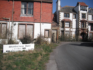
Start
at the small settlement of Skinburness. The original town was
engulfed in a flood in 1303, shortly after its harbour had been used
as a base for Edward 1's attack on Scotland. When I went there the
Skinburness Hotel was in a sad state of dilapidation. I was told that
the area was shortly to be developed into a retirement village.
Follow the coastal path down to the beach area. The Long House, now
converted into two cottages, overlooks the beach. It is said to be
the place where Bonnie Prince Charlie met the local Jacobites during
the ill fated uprising in 1745.
Walk
southwards, along the promenade, past the East Cote Lighthouse. This
was originally established in 1864 as a mobile structure on a short
rail track. It was fixed here in 1914 with a cabin below for the
keeper. The light was automated in 1930.
Continue
the walk down to Silloth and past some well tended, pleasant park
land. The resort is little more than 100 years old. Sometimes known
as Silloth on Solway it was developed in the 1860s when the terminus
of a railway from Carlisle was built (it was closed during the
infamous Beeching cuts of the 1960s). Before 1914 it was popular with
the middle classes who came here for 'the air'. After this it became
a destination for day trips for the working man and his family.
Although it has declined, major events such as a music festival are
attracting people again. It has a small port and large flour mill.
Look out for millennium sculpture celebrating the main features of
the town.
The
walk southwards out of Silloth is a little tricky as it involves
roads in the small dock area. Not very well marked when I went.
Eventually, you arrive on wide expanses of sand. The walk follows the
sand dunes although some can be done on the beach, and after a few
miles, along the road. For several miles I saw very few people.
Soon
after the path starts running parallel with the road you enter the
small village of Beckfoot. A notice here states that you must not
catch sea bass below the minimum size of 36cm. The sea here goes out
a mile leaving pools known locally as 'scars'.
About
4 miles further down is Allonby. The village was a hotbed of whisky
smuggling from Scotland in the 1700s.Look out for a large building
set back from the road. This is North Lodge built in 1824 by a
prominent Quaker called Thomas Richardson. He was a native of
Allonby and a generous benefactor of the village who allowed many
Quaker families to live rent free. The building is still owned by The
Society of Friends. Be very careful as you walk through the village
especially alongside the stream. There was a fatal accident involving
a walker the day before I was there.
Oyster
catchers, curlew, ringer plovers and the rare natterjack toad can be
spotted in the dunes near Allonby. A couple of miles south is South
Saltpan's Beach. It gets its name from an industry in Norman times
when salt was extracted from sea water.
The
only bit of hill climbing is on the outskirts of Maryport. Hadrians
Wall, originally thought to have finished at Bowness on Solway, is
now thought to have ended here at the site of the 1st
century 'Avna' Roman Fort. The walk goes past the site and a museum
is open to the public (but not when I was there).
As
you enter Maryport the path allows good views of the town. The
sunsets I saw were very attractive. More about the town on the next
walk.
Photos show: The old Skinburness Hotel - what is it like now?; The millennium marker, Silloth; North Lodge, Allonby; South Saltpans Beach; sunset at Maryport.


Thank you so much for posting this - we are trying to get information on walking from Maryport to Bowness via Skinburness but it has been hard to get firm details about distances and trail markings.
ReplyDeleteFound a few places like this around the English coast. Good luck with your walk.
ReplyDeleteWould anyone have info about the old families of the area who, for a fee, would safely guide walkers across the Solway Firth to Scotland at low tide?
ReplyDeleteThis was told to me by locals during my stay at Silloth.
I'd say that Grune Point is the best part of the whole of this walk. The pill box at Grune Point is of historical interest. It's been built if filled sand bags, unique. Its a fantastic place to use to watch wading birds. Winter time the marshes, are home to some of the biggest populations of geese and other waders in Britain. Fabulous easy walking in an area where there's not many accessible footpaths, because of farms and lack of wanting to make them accessible. Barbed wire and mud and ankle deep cow muck, Grune Point is a lovely place.
ReplyDelete