Total Pageviews

Thursday 5 December 2013

Walk 108 Lymington to Barton on Sea, Hants


 Walk  108 Lymington to Barton on Sea (Hants)

(Second leg of English coastal walk – Broadstairs to Lands End)

Map: L/R 196 and 195
Distance: 13 miles or 22km approx.
Difficulty: moderate
Terrain: paths and pavement
Access: Parking at both ends
Public transport: Rail links with Lymington and New Milton (a mile or so inland from Barton on Sea). Plenty of bus links in both towns.

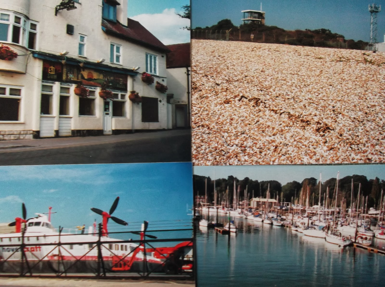
Walk south along the road to Lymington harbour and marina, both on the River Lymington. It is a busy town mainly due to the yachting centre, 
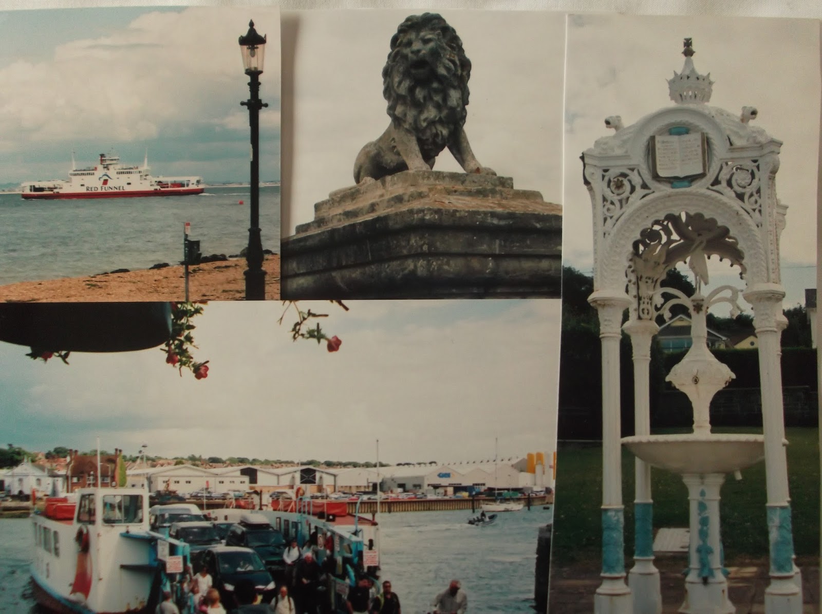
the proximity of the New Forest and the regular ferry to Yarmouth on the Isle of Wight. The town dates back to the 6th century when it got its name after the then marshy river. Since then the town has had a turbulent history including suffering destruction twice in 100 years at the hands of the French. Smuggling has been rife in the area. Before 1860 it was a major salt producer with much of the salt sold to the dockyards at Portsmouth to preserve meat. (Salt production died out when salt began to be mined in Cheshire).

On the walk from Lymington to Keyhaven there is clear evidence of past saltworks. Look out for the shallow pools which were constructed to allow the seawater to evaporate before being pumped into pans. The remaining brine was then boiled down to leave the salt. A series of narrow docks were constructed so coal could be brought in by ships and used in the boiling houses. When I walked along here work was going on to restore the salt marshes mainly to protect the specialist wildlife that thrives here.

The path continues to Keyhaven. If you fancy a drink, drop in to the Gun Inn. Part of the pub’s lounge was once known as the Chapel Bar because it was used as a temporary morgue for corpses recovered locally. Early in the twentieth century there were plans to dig a tunnel to the Isle of Wight and to convert the nearby marshlands into a dockyard.

Continue round to Hurst Beach and walk the shingly/pebbly part of The Solent Way to the end of the spit. Look out for the large rocks imported from Norway in the 1990s; these were put here to help protect the spit and the surrounding conservation area. The end of the spit is the English mainland that is closest to the Isle of Wight. Hurst Castle was built by Henry V111 and Charles 1st was temporarily imprisoned here in 1648 before his trial and execution. The castle was manned during the Napoleonic Wars and during World War 2. The building is open to the public and further information is available inside. The nearby impressive lighthouse replaces earlier lights and was built in 1867. It is still operational. There is a lighthouse exhibition in the castle for those wanting to know more.

Continue the walk along to Milford on Sea where the path overlooks the beach. Although the village goes back to the Domesday Book the lack of a rail link meant that it has never developed into a significant seaside resort. However, it is now a popular retirement area. Swimming can be especially dangerous when the sea is rough.

A little further along is Hordle Cliff. When I walked this section there was an interesting array of equipment on the cliff top. This belonged to a major study by scientists and engineers from Plymouth, Cambridge and Dundee universities. They were recording measurements on how the beach responded to waves, currents and water level changes. An acoustic wave and current profiler was deployed on the sea bed. I wonder if  restricted budgets have allowed this to carry on?

The path continues to Barton on Sea. The diminishing cliffs (erosion) are famous for fossils with specimens up to 45 million years old being found. On the road at Barton seafront is a memorial which commemorates the establishment of a convalescent home for Indian troops who fought in Europe during the Great War of 1914.
Snaps show: River Lymington; Keyhaven; rock defences on Hurst Spit; the cliff top, Milford on Sea.

Monday 11 November 2013

Walk 107 Hythe, Calshot, Lepe and Bucklers Hard (Hants)


 Walk  107  Hythe, Calshot, Lepe and Bucklers Hard (Hants)

(Second leg of English coastal walk – Broadstairs to Lands End)

Map: L/R 196
Distance: Four separate short walks totalling 3/4 miles at the most.
Difficulty: Easy
Terrain: paths and pavement
Access: Parking at all 4 locations
Public transport: Buses are possible from Southampton to Hythe (8 and 9) and from Hythe to Calshot (8). A passenger ferry from Southampton docks goes to and from the pier at Hythe. The other locations are to difficult to access using public transport.

This is one of those rare occasions when I have abandoned the idea of trying to walk from each location. It is no doubt possible using a lot of minor roads, mostly inland, but I prefer to focus on the coast only.

The first location is Hythe. Start at the marina and walk south to the pier which is a prominent feature. A passenger ferry to Southampton can be caught at the end. In 2003 a drunken captain of a dredger collided with the pier and it had to be rebuilt in 2004. The captain was jailed for 8 months. Hythe is a very old port with records going back to 1293. It was well positioned for trading, ship building and fishing. During World War 2 it was a base for motor torpedo boats and air sea rescue. The USA army also had a base here from 1968-2006. Christopher Cockerel (the inventor of the hovercraft in the 1960s) had his factory here.

The next stop is Calshot near the southern end of Southampton Water. Residents of the island of Tristan Da Cunha were evacuated to the village in 1961 when a volcano erupted. Many of them returned when the island was safe but some remained behind hence the community around Tristan Close. Looking west across the beach at Stanswood Bay the Isle of Wight is clearly visible. Walk to Calshot Spit with its activity centre and castle. The large activity centre is housed in hangars once used for flying boats and aircraft and in buildings once used by the navy. The facilities include an indoor climbing centre, a velodrome and a dry ski slope. The sea is used for many other activities.

The Royal Naval Flying Corps was based here in 1913. Look out for the two red brick buildings named after significant people. Lawrence House named after T E Lawrence (Lawrence of Arabia) was based here from 1929-1931. Houston House is named after Lady Houston who sponsored the R J Mitchell (of Spitfire fame) designed Supermarine which won the Schneider Trophy for the fastest seaplane. The competition was held here in 1931.

Near the end of Calshot Spit is Calshot Castle. This was built in 1540 by Henry V111 as part of his defence on the southern coast (device forts) when he split with the Catholic Church. From 1774 until 1956 it was used as a residence and is now owned by English Heritage. A moat surrounds the castle which can be visited at certain times. Calshot Spit is constantly changing shape due to gradual accretion and erosion. Nearby is a nature reserve. I was told that some unusual species live here due to the warming water that comes from nearby Fawley Power station.

The  next stop is Lepe where you can park very close to the beach. Looking west is Needs Ore Point which is in the estuary of the River Beaulieu. Henry 11 landed at Lepe to take possession of the English throne.

The last stop is Bucklers Hard. This owes its existence to the second Duke Of Montagu who aimed to create a port to import West Indian sugar. The idea came to nothing but a shipbuilding industry grew up instead and by the end of the 18th century 4000 men were employed here.  It was at Bucklers Hard that many of the ships that fought in the Battle of Trafalgar were built by Henry Adams and Sons. Nelson’s ship Agamemmon was built here and it was while commanding the ship in Corsica that he lost his eye. The famous Mulberry Floating Harbours were also constructed for the D Day landings in Normandy in June 1944. Their role was to keep the allied forces supplied.

There are a number of interesting features and places to learn more including a maritime museum, a chapel and a workman’s cottage.
Snaps show: Calshot Castle; Bucklers Hard; River Beaulieu; Hythe Pier.

Wednesday 30 October 2013

Walk 106 Hamble Le Rice to Southampton


 Walk  106  Hamble le Rice to Southampton (Hants)

(Second leg of English coastal walk – Broadstairs to Lands End)

Map: L/R 196
Distance: 10 miles or 15 km approx.
Difficulty: Easy
Terrain: paths and pavement
Access: Parking at both ends
Public transport: Bus 6 runs frequently between Southampton and Hamble Le Rice

Walk down the side of the River Hamble and past the large marina and then cross over to the oil terminals which are adjacent to Southampton Water.

Hamble Le Rice (until fairly recently known just as Hamble) was known for being an aircraft training centre during World War 2. It retains its links with aviation as many residents work at the Hamble Aerostructures Factory.

Look out for the large gun which points over Southampton Water near to the oil terminals. This is a similar anti-aircraft gun to that which used to protect the oil terminal during World War 2. If you are lucky enough to walk here at low tide you may see the remains of St Andrew’s Castle. This was built by Henry V111 in 1543 to defend against the French.

Soon after leaving Hamble is the Royal Victoria Park which extends up to the shoreline. These are the grounds of a former military hospital – the first purpose built one in the country. The construction was partly due to Queen Victoria’s horror at the conditions soldiers endured when injured in the Crimean War. The hospital was demolished in 1966 but the rather impressive green domed chapel remains. It can be visited as it is now a heritage centre.  The remains of a pier are nearby. This was built in 1865 and was originally 190 yards long. It was designed to receive hospital ships from all parts of the British Empire. After the hospital was opened in 1900 the pier was used by patients for fishing. It was demolished in 1955.

Walking northwards from here look out for the sculpted stone which was presented by people from the Basque area in Spain. It is a meeting stone once used by village people.

The walk continues northwards and passes by Netley Castle. This was originally a Tudor Blockhouse (a small detached fort) and was converted into a ‘show’ castle in Victorian times. The castle was a convalescent home for a long time but has now been converted into flats.

Continue the walk up to the Weston Shore, overlooked by some particularly unattractive blocks of flats. (Probably great views if you live in one). On the shore there are clear views to Southampton docks.

The walk into Woolston is along a road. This is an area I know well as my mother in law lived here for the last part of her life. She was a fierce opponent of The Itchen Bridge which is now a toll bridge into Southampton. I have to agree that, knowing the place before and after, it is a blot on the landscape. It was built in 1977 and replaced the floating bridge ferry (when I went it this had been converted into a restaurant). Woolston itself (as the name would suggest) was a wool trading port until about 1876 when ship building began. Vosper Thorneycroft had a large factory here that was closed in 2004.

Cross the Itchen Bridge into Southampton (walking is free). The help points along the bridge for those contemplating suicide seem to be depressingly necessary.

There is little of the coast that can be walked in Southampton. However, there are many historical points to look at around the old docks area. These include the 14th century town walls which were nearer to the coast than they are now. Through the Westgate archway of these walls marched the army of Henry V on its way to Agincourt in 1415.The pilgrim fathers embarked from the West Quay on the Mayflower in 1620.

Town Quay and West Quay are berths for cruise ships. There is also a ferry to Cowes on the Isle of Wight. Alongside the quays is Mayflower Park, this area was a spa resort in Georgian times and there was a waterside promenade for people to exercise. Jane Austen and her family frequently walked this shore. Less idyllic is the silver dome on the opposite shore – this is a waste incinerator.

Two of the significant buildings on the West Quay are Harbour House, now a casino and the Royal Pier Pavilion, now a Chinese restaurant. A pier was opened here by Princess Victoria in 1833 and in 1906 the pavilion was introduced. Like many other piers, fire destroyed much of it in 1987 and 1992.

Look out for the Platform Tavern down a side street opposite the quay. It dates back to 1873 and is of interest as it was built against the town wall. The tide from the River Test used to come right up to the town walls. There is a section of the wall which has been recreated to show where the boats would have been moored against the walls.   The pub gets its name from a part of the quay called The Platform – it contained a gun battery that was used for ceremonial purposes. The Woolhouse, now the maritime museum, is worth a visit. It was erected in the 14th century to store wool before it was exported. During the Napoleonic Wars it housed French prisoners of war.

This is only a flavour of Southampton. There is much of historic and cultural interest to look at if you have the time.

Snaps show: The Woolhouse, Southampton; Itchen Bridge, Woolston; Tudor Market Hall, Southampton; The gun emplacement at Hamble.

Wednesday 16 October 2013

Walk 105 Alverstoke to Bursledon (Hants)


 Walk  105  Alverstoke to Bursledon (Hants)

(Second leg of English coastal walk – Broadstairs to Lands End)

Map: L/R 196
Distance: 13 miles approx. or 20 km
Difficulty: Easy
Terrain: mainly paths, some shingle and pavement
Access: Parking at both ends
Public transport: Several buses from Alverstoke to surrounding areas – trains and buses from Bursledon

Start the walk in the Browndown area of Gosport, near Alverstoke. There is a permissive path mainly on shingle which runs alongside MOD land used for military training.  This finishes on arrival at Lee on Solent.

This small town got its name in the 19th century when there were serious attempts to develop it into a seaside resort. It had a pier built at this time but this was demolished in 1958. The town has long been associated with flying; seaplane trials started here in 1915. The Royal Navy base HMS Daedalus is here and the large red buildings back from the sea front provide accommodation for personnel working there. The actors Lawrence Olivier and Ralph Richardson trained as pilots here during World War 2. Look out for the hovercraft museum – large examples of these craft are clearly visible on the seafront.

After leaving Lee on Solent you arrive at Hill Head; its harbour was created by the movement of shingle. Prior to the 16th century this area was uninhabited and was sometimes referred to as Hell Head because of the dangerous waters.

A short distance from Hill Head is Titchfield Haven. This is a nature reserve nationally renowned as a winter refuge for ducks, wading birds and geese and a summer breeding area for the rare avocet.

I found the walk from here to Warsash rather chilly even on a summer’s day. On the other side of Southampton Water is the rather ugly view of the large oil refinery at Fawley.

After a few miles you arrive at Warsash with its distinctive clock-tower. The nearby Rising Sun is a particularly attractive pub and worth popping in for a drink. A plaque on the pub wall records the fact nearly 3000 hand picked and highly trained commandos embarked from the town on the day before D Day as a vanguard for the main assault. For those of us who remember it, the TV series Howard’s Way was partly filmed at Warsash.  A ferry departs from the harbour to Hamble Le Rice on the other side of the River Hamble – there is evidence of a ferry being here from the 1400s. The ‘hard’ where it lands is reputed to be very old. Look out for the Royal Thames Yacht Club (the oldest such club in the UK formed in 1775) who own an area here. In past centuries the town was important for ship building. The unusual name for the town is thought to come from the name of a seagrass meadow in the 1500s.

Continue the walk northwards along the River Hamble passing the marina near Bursledon. Near this point is the wreck of The Norseman, a wooden ship built in 1847; it was gutted by fire in World War 2 and beached on the mud. The Elephant Boatyard located in Old Bursledon was where Henry V111’s boats were built. The area including the Jolly Sailor pub was another location for filming of the TV series Howards Way.

Follow the A27 and bridge into Bursledon.
Snaps show: The Rising Sun at Warsash; the shingly beach from Alverstoke with MOD land in the background; hovercraft at Lee on Solent; Bursledon marina.

Thursday 3 October 2013

Walk 104 Portchester to Fareham then Hardway to Alverstoke (Hants)


 Walk  104  Portchester to Fareham then Hardway to Alverstoke (Hants)

(Second leg of English coastal walk – Broadstairs to Lands End)

This walk is split into two sections, the first could be done in the morning. I suggest a bus (or car ride) between Fareham and Hardway to avoid a rather boring road walk which is not on the coast. Completing the road walk from Fareham to Hardway will add roughly another 4 miles.   

Map: L/R 196
Distance: First half 4 miles or 7km approx. Second half 7 miles or 11km approx.
Difficulty: Easy
Terrain: paths and pavement
Access: Parking at both ends
Public transport: Regular train service to Portchester. First half of walk, buses run frequently from Fareham Bus Station to Hardway. Second half, several buses run from Alverstoke to Fareham.

Follow one of the minor roads off the A27 (or under the A27 south of Portchester Station). A path runs down the side of the coast opposite Horsea Island. Looking back from the path there is a good view of Portdown to the north of Portsmouth and Port Solent on the opposite bank.  After about three quarters of a mile you come to Portchester Castle.

This is an attractive ruin looked after by English Heritage. It has played an important role in the defence of the Solent for many years. It was originally built by the Romans in the 3rd century and is the only Roman stronghold in Northern Europe whose walls mainly stand to their full height. It became a Norman Castle in the 12th century and Henry V used it as a departure point for Agincourt in 1415; definitely worth a wander around the grounds. Look out for the gunpowder store which dates from about 1750 and was one of three built well away from the castle walls (for obvious reasons). The castle was regularly occupied by the military in the many wars of the 18th and 19th centuries when it was also used as a prison.

Follow the Kings Way from here and navigate on to the bus station at Fareham (if using public transport). The Kings Way or the Allan King Way is a 45 mile long distance path in Hampshire created by the Ramblers’ Association as a memorial to a former publicity officer.

Fareham is a market town which formerly used its clay soil for producing bricks, tiles and chimney pots.  Use the bus or car to Hardway as described above.

The coastal village of Hardway on the west of Portsmouth Harbour dates back to the Roman conquest. It was an area known for smuggling. The view now is mainly of ships and a small pier but for sometime in the past there was a local ‘hard’ where convicts were gathered for transportation. In 1770 the Royal Navy’s principal armament depot was situated nearby. This supplied arms from Nelson’s time to the Falklands War and was closed in 1989. The Explosion Museum situated on Priddy’s Hard tells the story of the arms depot. It is supposed to be one of the most haunted locations in the UK with many people reporting strange events thought to be associated with the several people who died whilst working in the depot or being deported from the ‘hard’.

Continue walking south. An impressive looking sea mine is situated near some beach huts. This is an example of a buoyant acoustic mine which is activated by the noise of approaching ships. It was used in World War 2 - the whole area played an important role in the war. Repairs and refuelling of navy ships took place and D Day embarkations were from near here in 1944.

Follow the path along the road past the marina, hospital and prison. The path then skirts a golf course before it reaches Gilkicker Point, the most southerly point of the area. On the left is Fort Gilkicker one of a series of twenty forts built in the 1860s under the instructions of Lord Palmerston (then prime minister) to encircle Portsmouth. They were supposed to counter a threat from Napoleon 111. None of them were used in serious combat and they became known as Palmerston’s Follies.

Continue the walk along Alverstoke seafront which looks out on to Stokes Bay. Fourteen Mulberry Harbours (floating piers) were built here in 1943 and 1944. In earlier times it was a vital part of the defence against the Spanish Armada.

At the end of the golf course navigate inland to Alverstoke. There were ambitious plans in the 19th century to develop an area called Angleseyville into an exciting holiday area. Look out for the Anglesey Arms Hotel which was the only part of this plan to be completed - an impressive building where Queen Victoria stayed on her way to the Isle of Wight. Buses leave from various points in Alverstoke.

Snaps show: Portchester Castle; a gunpowder store at Portchester Castle; Gosport Ferry; acoustic mine at Hardway.

Saturday 14 September 2013

Walk 103 Isle of Wight - Gurnard Bay to East Cowes

Walk  103  Isle of Wight- Gurnard Bay to East Cowes

 (Second leg of English coastal walk – Broadstairs to Lands End)

Map: L/R 196
Distance: about 5 miles or 8 km including exploring the towns
Difficulty: Moderate
Terrain: mainly pavement
Access: Parking at both ends
Public transport: Bus 1 runs from Newport to Cowes. Further bus connections at East Cowes. The walk involves using the floating bridge to cross the River Medina to East Cowes. 

This is quite a short walk that could be combined with a visit to Carrisbroke Castle in nearby Newport. This is the castle where Charles 1st was kept before his execution in London. A museum tells the story of the castle including that of the donkeys which still turn the water wheel (for demonstrations only).

Gurnard Bay has a small beach with a few beach huts. The view across the sea is quite pleasant with the not so nice industrial area of Fawley just visible in the distance. The walk into Gurnard and Cowes follows the road. Look out for some quite impressive houses on the way to Egypt Point. This part of the coast gets its name from a gypsy encampment that was nearby in the sixteenth century. Between 1897 and 1989 a lighthouse operated here and the structure is now used as a landmark for yachtsmen. Egypt Point was one of Queen Victoria’s favourite spots when she lived on the island. Look out for an impressive and elaborate water fountain with a carved open bible on its roof. I have been unable to find out the significance of this although it clearly has some religious origin.

Ferries coming and going to Southampton can be regularly seen on the walk into Cowes. The town is probably the most famous and fashionable yachting centre in the world. Cowes Week takes place during the first 9 days of August when there are several regattas. East and West Cowes are split by the River Medina. On the west side are some smart brass cannons pointing out to sea, these come from a fort built by Henry V111 to defend The Solent. During World War 2 Cowes was the centre of operations for the D Day landings.

There are several yachting clubs in West Cowes. The Royal Yacht Squadron founded in 1815 is regarded as the most exclusive in the world. There is also a strong boat building tradition in Cowes. Personalities who have a connection with the town include Ellen McArthur, George V, Edward V11 and William Arnold. The latter, who was the father of Thomas Arnold, fought against the pirates and smugglers active here in the 19th century.

The floating or chain ferry carries foot passengers and cars to cross the River Medina. Before the 1860s the ferry was horse drawn. During the 19th century Cowes was a fashionable spa town with bathing machines. Look out for the ‘unclaimed shop’ (if it is still trading) – this sells or sold lost property.

The walk around the Isle of Wight finishes here.

Snaps show: Southampton to Cowes ferry; the lion sculpture at Egypt Point; the water fountain near here; the chain ferry.

Sunday 25 August 2013

Walk 102 Isle of Wight - Alum Bay to Yarmouth


 Walk  102  Isle of Wight- Alum Bay to Yarmouth

(Second leg of English coastal walk – Broadstairs to Lands End)

Map: L/R 196
Distance: 6 miles or 11 km. approx.
Difficulty: Moderate
Terrain: mainly footpaths
Access: Parking at both ends
Public transport: No 7 bus runs regularly between the two points

From Alum Bay continue the walk across Headen Warren before dropping down into Totland.

There were some strange sculptures in the rocks when I walked along here. Bent iron poles with bits hanging from them stuck into the rocks Are they still there I wonder. The pier at Totland is used by Trinity House for taking out pilot boats and guiding ships into The Solent.

Continue to Colwell Bay. After the path cuts inland there is a building jutting out into the sea. This is Fort Albert built in 1856 as a defence against the French. It was used in later years for the first torpedo development trials.

On the walk into Yarmouth the path passes through the Fort Victoria Country Park. If there is time you may want to visit some of the attractions here. They include an aquarium, an underwater archaeology centre, a planetarium and a model railway.

After a little bit of road walking you enter Yarmouth. This is an attractive town, situated at the mouth of the River Yar and the oldest one on the island. It is listed in the Domesday Book and was the first town to be granted a royal charter. The town cannot be enlarged from its present size as it is surrounded by solid rock. Yarmouth Castle was built by Henry V111 in response to the sacking of the town (twice) by the French. The 215 metre pier dating from 1876 is unique in Britain as it is the only one remaining built entirely of wood (apart from screws, nails etc.) It is a listed building. The interestingly named Old Gaffer Festival takes place in Yarmouth every May or June. A gaff is a specially rigged sailing boat and about 100 of these compete in a three day festival.

Snaps show: The rock sculptures at Totland; Yarmouth Pier; part of Yarmouth town; Totland Pier; Fort Albert, Colwell Bay.

Thursday 15 August 2013

Walk 101 Isle of Wight - Brighstone to Alum Bay


Walk   101  Isle of Wight- Brighstone to Alum Bay

(Second leg of English coastal walk – Broadstairs to Lands End)

Map: L/R 196
Distance: 13 miles or 20 km. approx.
Difficulty: Moderate
Terrain: mainly footpaths
Access: Parking at both ends
Public transport: A little tricky but possible with buses from Brighstone to Alum Bay changing at Totland.

The coastal path continues from Brighstone and runs parallel to the main road. Hopefully, there will be no further damage to the cliffs that necessitate walking along the road. From Brook Bay there is a good view of Hanover Point with its white cliffs and Compton Bay beyond. This area is famous for evidence of dinosaurs including the discovery of iguanodon footprints fossilised in the mud. This part of the coast is preserved by the National Trust.

Shippard Chine is crossed by a small footbridge and a further one at Compton Chine. The next main feature is Freshwater Bay. This is a picturesque cove overlooked by a hotel (with a bar!). The nearby village of Freshwater was the birthplace of Robert Hooke the famous physicist.

There is a climb out of Freshwater Bay on to Tennyson Down with its distinctive monument. This is dedicated to Lord Tennyson  (1809-1892) who lived near Freshwater from 1853 to 1868. It stands 482 feet above sea level and the air here was described by Tennyson in one of his poems as worth ‘sixpence a pint’.  The views from here are impressive.

Continue the walk around to the Needles. The iconic, instantly recognisable, view of the rocks is seen best from Alum Bay  or Needles Old Battery. The latter, now owned by the National Trust is worth a visit. It is a fort from the 19th century and was also used in both World Wars. Exhibitions in the fort explain its history and there is an underground tunnel which leads to a lookout.

Continue around to Alum Bay. A chair lift down to the beach is the best way to view the banded sandstone cliffs. These have more than 20 colours ranging from chocolate brown to strawberry pink. It is now prohibited to take sand from the beach or cliffs. However, glass containers with samples can be bought from the cliff-top shop.

At the top of the cliff there is a small amusement park with cafes etc. A memorial near to the chairlift marks the site of the Needles Wireless Telegraph Station. Marconi and his British collaborators carried out a series of important experiments from here between 1897 and 1900. In 1899 information for the first newspaper produced at sea was transmitted from this spot - to the ‘St Paul’ which was 36 miles away at the time.

Snaps show: Freshwater Bay looking east; the rocks at Alum Bay; The Needles from the battery; the chair lift at Alum Bay; Freshwater looking west; a cannon at Needles Battery.

Friday 26 July 2013

Walk 100 Isle of Wight. Ventnor to Brighstone


 Walk  100  Isle of Wight- Ventnor to Brighstone

(Second leg of English coastal walk – Broadstairs to Lands End)

Map: L/R 196
Distance: 15 miles or 23 km approx.
Difficulty: Moderate
Terrain: Mainly footpath and pavement
Access: Parking at both ends
Public transport: Possible but tricky, two buses via Carrisbroke or Newport – check Traveline website.

Start walking on the coast path west out of Ventnor. You will come across a large sign of ‘VENTNOR’ carved into the Cliffside. This marking first appeared in 1934. When war broke out in 1939 it was removed for obvious reasons but it has been refurbished several times since then.

About a mile further along is Castle Cove. This is one of a small number of bays caused by the erosion of soft rocks between headlands of more resistant materials. Steephill Castle was built here in the 1830s and was demolished in 1910 - hence the name of the cove. It was a mansion built in the style of a castle.

On this walk a number of thatched cottages can be seen. Also on this path there is a derelict building in the shape of a hut – perhaps it was a fisherman’s cottage or possibly a fish smoking hut.

Soon after St Lawrence, the path goes across the downs with good view of the sea. The start of this walk is called the Undercliff – a narrow strip of land-slipped terrain between the sea and the high cliffs. After a few miles, following The Pilgrim’s Path, (not quite sure why it is called this) there is a good view of St Catherine’s Lighthouse which was built in 1840. It is one of the most powerful lighthouses in the UK with a range of 26 miles.

After Blackgang Chine (where there is an activity centre, rides and Victorian cliff-top gardens) follow the path and road to Chale. At this point the path leads back to the coast with views of Chale Bay and its red sand. The path goes past Atherfield Point then Shepherd’s Chine. A chine is a deep cut ravine. Views near here of Compton Bay.

When I walked this section much of the coastal path was closed due to erosion and I had to walk mostly along the main road to Brighstone. During this long, boring and dangerous walk (no pavements) I came across a bus stop with the name ‘Middle of Nowhere’ – the X40 bus stops here. I agree with the description but wondered who on earth gets off in the middle of nowhere!

The walk finishes at the old village of Brighstone (previously known as Brixton – where I was born - but in London). St Mary’s Church has stood for 8 centuries and there is an old shop and museum owned by the National Trust. It displays information about village life in the past and celebrates the achievements of the Brighstone lifeboats. The pub (tried and tested and gets a tick), The Three Bishops, is named after three rectors from here who went on to become famous bishops.
Snaps show: Shepherd's Chine; Castle Cove; two views across  Chale Bay including the red sand.


Wednesday 17 July 2013

Walk 99 Isle of Wight Bembridge to Ventnor


 Walk  99  Isle of Wight- Bembridge to Ventnor

(Second leg of English coastal walk – Broadstairs to Lands End)

Map: L/R 196
Distance: 10 miles or 17 km approx.
Difficulty: Moderate
Terrain: Mainly footpath and pavement
Access: Parking at both ends
Public transport: a bit long, bus 8 from Bembridge to Ryde then Bus 3 from Ryde to Ventnor - (takes about 1hr 30min).

Start on the coastal path at Bembridge, this cuts inland on the map but I managed to find a way along the sea front. After about a mile you get an attractive view of Whitecliff Bay. The cliffs here are made from soft clay and they are constantly crumbling and slipping. Be aware that path diversions are possible here and on other sections of the walk around the Isle of Wight.

During the 1920s and 1930s huts and chalets were built above the beach at Whitecliff and people lived in them during the summer. Boys’ Brigade and Girl Guides have been camping around the area since the 1900s. As can be seen, there are many caravans here now and this has been the case since the Second World War. I understand some of them are quite luxurious.

The next major landmark is at Culver Cliff on the edge of Bembridge Down. An impressive monument to Lord Yarborough cannot be missed. His ship, The Falcon, a 20 gun ship of war, was launched in 1926. In 1827 he was involved in the battle of Navarino and in 1835 he was badly injured in a gale when on the ship. He bought a smaller ship later but died suddenly in 1846. He was Commodore of the Royal Yacht Squadron at Cowes hence this memorial on the island. 

The walk continues along cliffs with views to the town of Sandown. The town grew very quickly after the railway was built here in 1864. Its charms had been recognised by famous celebrities of the day including Charles Dickens, Lewis Carroll, George Elliot and John Keats. Sandown remains very popular with holiday makers with its sandy beaches and pier. Look out for the Dinosaur Museum which celebrates the fact that this is a good place to look for fossils. The pier dates back to 1879 and despite a major fire in 1989 (why do piers suffer from so many fires?) is now thriving with indoor attractions. Some good photos can be taken from the end of the pier which is open all year.

The next town is Shanklin. It became a fashionable spa after the arrival of the railway in 1864. Its waters were found to be rich in iron salts with considerable healing powers. If you have time, it is worth a visit inland to the old village of Shanklin with its picturesque buildings.

The path to Ventnor is inland and follows a road for some of the way. The path returns to the coast near Monks Bay. Nearer to Ventnor are some intriguing conical type rocks that look like they are sea defences. I have not been able to establish why they are this shape.

Ventnor stands on terraces below St Boniface Down which, at 785 feet, is the highest point on the island. The resort was established in Victorian times. The area has its own microclimate and experiences more sunny days than much of the UK. This has led to the establishment of the Botanical Gardens which are able to support sub-tropical plants. Worth a visit if you are interested. Brian Murphy the man who played George in George and Mildred on TV was born here.

Snaps show: Sandown Beach; Whitecliff Bay; Lord Yarborough monument; the sea defences at Ventnor; Ventnor front.


Saturday 29 June 2013

Walk 98 Isle of Wight - Fishbourne to Bembridge


 Walk  98  Isle of Wight- Fishbourne to Bembridge

(Second leg of English coastal walk – Broadstairs to Lands End)

Map: L/R 196
Distance: 11 miles or 18 km approx.
Difficulty: Fairly easy
Terrain: Mainly footpath and pavement
Access: Parking at both ends
Public transport: A little tricky, it involves getting a number 9 bus at Fishbourne and changing en route to a number 8 for Bembridge. Go to Traveline website for more details.

Public access to the coast between East Cowes and Fisbourne was not possible when I visited and no public paths are marked on the map. However, while in this area it is well worth visiting Osborne House designed by Queen Victoria and Prince Albert. It was their second home and Queen Victoria died here. A good view of their private beach can be had from the house.

The walk starts on the coastal path near Fishbourne close to Wooton Creek. The ferries going into the port at Fishbourne can be seen from here. The path makes its way inland to Ryde with only brief glimpses of the sea (Ryde Roads). One distinctive landmark is Quarr Abbey. This was erected by French Benedictine monks between 1908 and 1914. It is built on the site of a medieval abbey dating back to 1132 and destroyed in 1536 at the time of the Dissolution.

The walk into Ryde passes a lake adjacent to the beach where some odd boats are made in the shape of very large swans! Ryde pier is half a mile long and is the fourth longest in the UK. A railways runs along the pier and there is an electric rail connection from the pier to nearby Shanklin. The trains are ex London Piccadilly underground trains. Ryde has been a point of strategic defence and was fortified by cannons against a possible invasion by France in Napoleonic times. The front is neat with a few attractive buildings. The beaches are sandy and very popular. On the way out of Ryde, and near to the beach, is Appleby Tower, a Victorian watchtower. You can go to the top of this on certain dates and you can also have your fortune told!

Continue round to Nettlestone Point where the beach is stony and there is a large wildlife park. The coastal path cuts inland soon after this and returns to the coast at St Helens.

St Helen’s Church, on the beach near St Helens, is a significant landmark. It was built about 1220 and ceased to be used in 1703 when it was bricked up. At this point it became a source for 'holy' stones which were taken by sailors to scrub down the decks of wooden ships. On the 14th September 1805 Lord Nelson boarded HMS Victory, which was anchored nearby, to sail to the Battle of Trafalgar.

Follow the path across Bembridge Harbour. I noted a very interesting guest house (4 star) formed from a houseboat and guarded by two statues of pirates! Bembridge village is inland up a hill. It is worth a visit if only to see the windmill – the only one surviving on the Isle of Wight. It was known to be in existence in 1740 but may well be older. Turner started a water colour of it in 1795 (not sure whether it was finished). There was at least one woman miller in the past. The mill was last used in 1913.

The beach at Bembridge is very picturesque although the infamous ‘Ledges’ lie off the beach and several ships have foundered on these. The Crab and Oyster pub is adjacent to the beach if you fancy a drink and/or a meal.

Snaps show: St Helen’s Church; Osborne House; Appleby Tower, Ryde; Bembridge Bay.


Tuesday 11 June 2013

Walk 97 Hayling Island to Portsmouth


 Walk  97  Hayling Island to Portsmouth

(Second leg of English coastal walk – Broadstairs to Lands End)

Map: L/R 197 and 196
Distance: 13 miles or 22km
Difficulty: Easy
Terrain: Mainly footpath and pavement
Access: Parking near The Ship Inn, Langstone and in Portsmouth
Public transport: Rail to Havant and walk to Langstone Bridge. Main line rail at Portsmouth where there appear to be plenty of buses to various destinations.

Starting on the mainland side of Langstone Bridge follow the path westwards and along the roads (including the main road) until joining the Solent Way to Farlington Marshes. This is a wildlife trust where notices caution you to take care of the protected species. Dogs must remain on their leads. I came across at least 100 birdwatchers sporting expensive equipment walking excitedly down the path. The snippets of conversation suggested that something rare had been spotted. An information board helps to identify the birdlife and some of the 300 species of plant found here. It is particularly rich in grasses – one third of the British types are said to grow here.

Follow the road, then turn left onto the path that skirts the edge of Portsea Island. This is not a walk of great beauty. The path is a fairly rough one and there is a need to return to the road at times. Apart from a sad memorial to a young dancer and good views of Hayling Island there is little to be said about this part of the walk.

The next main feature is the Royal Marines Museum opposite Eastney seafront. The old barracks nearby have been turned into flats. The eastern part of the beach at Eastney is designated as a danger area presumably because of unexploded shells etc.

Continue the walk to Southsea. Some quite impressive seafront buildings sit alongside more modern constructions. The beach is mainly gravel with sand exposed at low tide. The promenade goes past the South Parade Pier. This has been closed recently due to health and safety concerns. It was dismantled during World War 2 as it was feared it could aid an invasion. The pier, which includes a ballroom and a bar, was featured in the film ‘Tommy’.

Parallel to the seafront is Southsea Common which boasts some impressive elm and palm trees. The town, which is really part of Portsmouth, was built up in the early 1800s initially to house skilled workers. It was heavily bombed in World War 2.

Southsea Castle built by Henry V111 is near to a lighthouse. It was from a spot near here that Henry saw his flagship The Mary Rose sink. This partly restored ship can be seen in Portsmouth dockyard.

The large naval memorial listing those lost in shipwrecks stands prominently to the right of the promenade. Looking seawards this is a good spot to watch the various crafty coming in and out of Portsmouth harbour. Look out for the Nelson statue and the anchor from his flagship HMS Victory.

Further along is Clarence Pier built in 1861. This area features amusement arcades and fast food outlets. The pier was the location of Mind the Baby Mr Bean on TV! Looking out so sea a few concrete constructions can be seen. These are sometimes known as Palmerston’s (the Victorian prime minister) folly. He ordered them to be built as a defence against France when an invasion seemed likely. During World War 2 they came back into use when used as anti aircraft bases.

As you progress into Portsmouth there are several waterside forts to be seen - most were begun in the 1400s. Look out for Sally Ports which are openings in the fortifications enabling people to look out on to the harbour or estuary.

Walk along to Old Portsmouth where there is a part called Spice Island. Spices from the Caribbean once landed here and sailors frequented the many pubs which were open 24 hours a day. Press gangs roamed the streets on the lookout for unsuspecting drunks to put on ships as forced labour. A ferry runs from near here to Gosport on the other side of the estuary; Portsmouth Harbour Station serves this ferry.

Not be missed is the Spinnaker Tower. It is worth the money to go up the tower and experience a panoramic view of the whole area. The tower is 170 metres high and was opened in 2005. It takes its design from the main sail of an ocean going yacht. From here can be seen the waterside which consists of apartments and shops at Gunwharf Quay. The naval dockyard can also be seen and is well worth a visit if you have plenty of time. HMS Victory, HMS Warrior and The Mary Rose are among the attractions.
Snaps show: Spice Island, Portsmouth; Clarence Pier, Southsea; view to the dockyard from Spinnaker Tower; Gosport Ferry, Porstmouth. 


Monday 3 June 2013

Walk 96 Hayling Island


 Walk  96  Hayling Island (Hampshire)

(Second leg of English coastal walk – Broadstairs to Lands End)

Map: L/R 197
Distance: 10 miles or 15 km
Difficulty: Fairly easy
Terrain: Mainly footpath and pavement
Access: Parking near The Ship Inn, Langstone
Public transport: Rail to Havant and walk to Langstone Bridge. Return journey from Eastoke area of Hayling Island on 30 or 31 bus back to Havant – runs every half and hour or so Mon-Sat.

Start on the Havant side of Hayling Island. Walk past the Ship Inn before crossing Langstone Bridge. This pub, which was originally a mill, is worth making a note of especially if you like real ale and/or seafood. As you begin to cross the bridge look back to the east and an old windmill (a well known local landmark) can be spotted. The original bridge was timber built and replaced the Wadeway in 1824. This foot crossing, used for 3000 years, is still visible at low tide. The current bridge was built in 1956 to replace the fragile timber original. Before this date bus passengers had to get off on the mainland and continue their journey on the other side.  

To the west of the island is Northey with its marina and nature reserve to the south of Northey Manor. However, the eastern coastal part of the island is mostly inaccessible so the walk concentrates on the western and southern sides.

On the other side of Langstone Bridge find the start of the Hayling Billy Coastal Path which follows the route of the old rail line along the west coast of the island. The line started at Havant and was opened in 1867. It was closed in 1963 as part of the cuts imposed by Dr Beeching. Special lightweight engines were used so that the old Langstone Bridge could be safely crossed. The Hayley Billy Terrier Tank Engines now form part of the Isle of Wight steam railway. The path gives some good but not continuous views of the coast. Portsea Island can be clearly seen to the west.

At the end of the old railway line some careful navigation along the roads will lead you to an area called The Kench. This is an inlet where failed attempts were made to construct a marina. During the 1950s several surplus military boats were purchased and converted into house boats. I spotted a few still in use as living accommodation.

Continue walking to the western point of the island and the Ferry Boat Inn. The pub was originally called The Norfolk Lodge as the Duke of Norfolk owned much of the land in South Hayling. The timbers used to build it were from HMS Impregnable (clearly not!) which sunk here in 1798. It changed its name in the 1950s to capitalise on a popular song at the time “Down at the Ferry Boat Inn”.   A passenger ferry runs from here to Portsea although a local told me it remains under threat of closure as it is subsidised by the local authority.    

Follow the path on to the southern coast of the island and past Sinah Common with its golf course. Hayling Golf Club was founded in 1883 by Colonel Sanderson who was a famous producer of sherry and port.  This area is of special scientific interest and the rare Dartford Warbler has been sighted here.

Continue the walk along the sea front past The Inn on the Beach and then to various flats and buildings overlooking the large grass frontages and dunes. Norfolk Crescent and the impressive white building – The Royal - were part of a failed attempt in the early nineteenth century to create a grandiose development to attract wealthy visitors.

The beach is mainly of pebbles although I thought it once had grey sand when I visited here as a child in the 1950s/60s. A local suggested that the beach had been manually filled with gravel and pebbles to prevent erosion. A fun fair and a 2 foot gauge railway operate along the front in the season.

The path continues towards Eastoke Point. A number of bungalows are close to the beach – some with interesting gardens made of beach debris. From this point there are good views back to Chichester Harbour.  
Snaps show: The Ferry Boat Inn; The Kench; The Royal and Norfolk Crescent; one of the interesting beach gardens.

Saturday 11 May 2013

Walk 95 Southbourne - Thorney Island - Emsworth

Walk  95  Southbourne - Thorney Island - Emsworth (Hampshire)

(Second leg of English coastal walk – Broadstairs to Lands End)

Map: L/R 197
Distance: about 10 miles or 15 km.
Difficulty: Easy
Terrain: Mainly footpaths, some pavements
Access: Parking at both ends
Public transport: Rail link between Southbourne and Emsworth

Take one of the paths out of Southbourne which connects with the coastal path that passes along the northern edge of Thorney Channel. This area abounds with coastal defences. Continue westwards until Thornham Marina (near to the village of Prinsted). Form here there is access to Thorney Island.

The island is under military control and before starting your walk a secure gate has to be opened. Be prepared to give information over the intercom including your name, age, address, phone number, nationality and the reason you want to visit the island. If the military are satisfied they will open the gate but not before warning you to keep strictly to the path. Makes you wonder what is on there! Just in case you forget there is a notice telling you that trespassers will be prosecuted and that guard dogs are on patrol. A similar procedure is waiting for you when the walk is finished.

About a mile or so in is West Thorney – not that you can see much of it. For a while in the 1970s village was home to several hundred Vietnamese ‘boat people’ who were accepted into the country for settlement. Since that time the area has been in the control of the Royal Artillery. I understand that the 12th century St Nicholas’s Church, which can be seen from the path, is open to the public. The path to it did not look very inviting to me and, bearing in mind the dire warnings I had received, I decided to give it a miss.

On the southern most tip Pilsey Island can be seen; this is home to an RSPB nature reserve. Near here is Thorney Island Sailing Club and a model aeroplane club was also in action when I was walking. As the path continues northwards the runways of the old RAF aerodrome (built in 1938) are evident. Hayling Island can also be seen to the west.

I met nobody else on this walk but I did have an altercation with a lot of cows. These had been released by the farmer (deliberately??) to completely block the path and the ground either side of it. I was forced to walk through the obstinate creatures who made their displeasure clear by releasing considerable quantities of, let’s say, dung, at my feet.

The walk ends in Emsworth. To the east of the town is Skipper Mill Pond which was built in the 1780s; the mill was converted into homes after it ceased functioning in 1936. An attractive street leads to Emsworth Quay. There was once large oyster beds here but the business came to an unfortunate end following a banquet held by the Dean of Winchester in 1903. The dean and several of the guests died of typhoid as the oysters had been infected by sewage flowing into the harbour.  

Look out for the old tide mill on the sea front which is now the HQ of a sailing club. This dates back to 1760 and was once operated by steam power. This is an attractive spot.

Snaps show: parts of the path and coast on Thorney Island; St Nicholas Church, West Thorney; Thornham Marina.


Sunday 28 April 2013

Walk 94 Bosham to Southbourne (West Sussex)


 Walk  94   Bosham to Southbourne (West Sussex)

(Second leg of English coastal walk – Broadstairs to Lands End)

Map: L/R 197
Distance: about 8 miles or 13 km.
Difficulty: Easy
Terrain: Mainly footpaths, some pavements
Access: Parking at both ends
Public transport: 55A Bosham to Chichester every hour or so Mon-Sat (a few on Sundays). Rail link to Chichester at Southbourne

There is not too much to write about this quiet and pleasant walk.


Follow the path to the north out of Bosham until it meets the A259. Walk west along this road (which follows the route of the old Roman road) and turn down the footpath that leads to Chidham.

This village, which is a little inland from the coastal path, has been occupied for more than 4000 years (recent finds have confirmed this). The name Chidham is derived from ‘ceod’ (meaning bag or pouch) and ‘ham’ (meaning settlement) – it refers to the shape of the peninsula. St Mary’s Church, Chidham was built in the 13th century.

On the walk around the peninsula a number of flood defences can be seen including piles of rocks in fields. Cobnor Point is at the southern most tip and there are good views across Chichester Channel to the West Itchenor area.

On the walk northwards is Chidham Point which provides good views of Thorney Island opposite. Around here is the Nutbourne Marshes Nature Reserve – a saltmarsh which is an important habitat for wildfowl and waders.

Follow the path round into the now expanding village of Southbourne.

Snaps show sea defence in a field; a caravan at Chidham; view from Cobnor Point; view from Chidham Point.


Monday 8 April 2013

Walk 93 East Wittering to Bosham


 Walk  93   East Wittering to Bosham (West Sussex)

(Second leg of English coastal walk – Broadstairs to Lands End)

Map: L/R 197
Distance: 11 miles or 16km approx.
Difficulty: Fairly easy – stony beach walking can be tiring
Terrain: Paths, pavements, beach  
Access: Parking at both ends
Public transport: 52/53 frequent service from Chichester to East Wittering Mon – Sat (once and hour on Sunday). 55A Bosham to Chichester every hour or so Mon-Sat (a few on Sundays).

This walk can only be done between mid May until the end of September as it involves using the West Itchenor ferry.

The first part of the walk from East Wittering/Bracklesham Bay is along the pebbly beach. A very large caravan park is on the eastern side with some interesting modern houses overlooking the beach. Portsmouth and the Isle of Wight are usually visible from here. The beach was used by Canadian forces to practise for D Day in 1944. Now it is very popular with surfers.

Continue the walk on the path alongside the sandy shoreline to the entrance to Chichester Harbour. Some of the houses along this stretch have their own beach gardens. There is a choice at the end of this path either take a walk around East Beach or turn right and continue past West Wittering. The sandy dunes along here make it a pleasant spot to sit and rest. Much of the area is managed by The National Trust and it has a range of wildlife specific to the conditions.

The walk continues past West Wittering through an area called Snowhill (no snow, no hill). Carry on to West Itchenor, a village which appears to be dominated by the sailing community. Catch the seasonal ferry from here to Smugglers Lane on the other side. As the name suggests there was a lot of smuggling in the area especially the sending of brandy into Chichester. The ferry dates back to the 17th century and, following a period when it was out of use it was reinstated in 1976.

Follow the path into Bosham which is a very attractive place. When the tide is in it covers the road and you can see how houses have been specially adapted to cope with this. If the tide is out there is an extraordinary, picturesque stretch of green algae instead of the water.

The village goes back to Saxon times. Legend tells of a Danish raid in which the church bells were stolen. The Danish ship sank in the channel and the lost bells are said to ring in answer to the present bells. It was at Bosham that King Canute supposedly tried to turn back the waves (other places make this claim as well) – legend also has it that his young daughter was drowned in a millstream nearby and was buried in the church. In 1865 an excavation found the bones of a girl about 8 years old so maybe it is true. Bosham Church is depicted in the Bayeux Tapestry showing King Harold going in there to pray for safe passage to Normandy in 1064.

Snaps show: East Head, Chichester Harbour; buildings on the beach Brackleshem Bay; Snow Hill; Bosham.


Monday 18 March 2013

Walk 92 Pagham to Selsey


Walk   92   Pagham to Selsey (West Sussex)

(Second leg of English coastal walk – Broadstairs to Lands End)

Map: L/R 197
Distance: 10 miles or 16 km approx.
Difficulty: Easy
Terrain: Paths and pavement
Access: Parking at both ends
Public transport: 51 bus from Selsey to Chichester, 60/700 Pagham to Chichester

Start at Pagham and take the path that skirts around the edge of Pagham Harbour to Church Norton. This is a pleasant, peaceful walk with good views.

Pagham Harbour is 1000 acres of natural saltmarsh, lagoon and tidal mudflat. It is now a significant nature reserve with 200 species of birds, 340 varieties of flowering plants and even 13 species of woodlice. There was a harbour here from 1345 until 1875 but it became silted up and much land was reclaimed. However, in 1910 a combination of high tide and heavy rain punctured the sea wall and the water spilled back in.

To the south of Sidlesham there is walk along the main road before returning to the path. Look out for the old thatched cottage and the many geese.

At Church Norton is St Wilfred’s Chapel, it is still used and was open to visitors when I went. The main church which gave the settlement part of its name was moved to Selsey in 1865. A large graveyard provides evidence of a much larger population in the past.

On the approach to Selsey some conversions of old railway carriages are easy to spot. Look out for the plaque to Eric Coates who was inspired by the view back to Bognor Regis and composed The Sleepy Lagoon in 1930; this became the signature tune for the BBC radio programme Desert Island Discs.

The walk continues along the promenade to Selsey Bill, this low lying headland is the most southern point of Sussex and has eroded more in the last century than any other part of the UK. The famous Mulberry Harbours were assembled off Selsey. Sections of concrete were assembled, towed to the Normandy Beaches and used in the D Day landings of 1944.

Walk past the lifeboat station and pier to the beach at West Selsey. Here there are some strange looking conical stone structures on the beach – I have not been able to find out what these were/are for.

Selsey was the centre for a thriving mousetrap industry in Victorian times. They were taken by cart to Chichester and exported to countries around the globe – evidently they never wore out! A famous resident in the distant past was St Wilfred the patron saint of Sussex and one time Bishop of Northumbria. He was shipwrecked here in the 7th century and returned a few years later to found a monastery, which, because of the sea encroaching, was later moved to Winchester. A more recent resident of Selsey was the astronomer Patrick Moore.
Snaps show: two views of Pagham Harbour; St Wilfred's Chapel; Selsey Bill.


Thursday 7 March 2013

Walk 91 Littlehampton to Pagham


Walk   91   Littlehampton to Pagham (West Sussex)

(Second leg of English coastal walk – Broadstairs to Lands End)

Map: L/R 197
Distance: 11 miles or 18 km approx.
Difficulty: Easy
Terrain: Paths and pavement some beach walking if preferred
Access: Parking at both ends
Public transport: regular buses from Littlehampton (700) change at Bognor Regis for 60 to Pagham.

Take the walk out of Littlehampton along the west bank of the River Arun then follow the path which runs along the edge of the golf course to Climping Beach and the small settlement of Atherington. From here to Bognor Regis access to some of the beaches is restricted as they are privately owned. If you walk below the high tide mark then (so I have been told) it is OK as this part is not owned by anyone. However, I tend not to do this having been bitten by a dog which was released by its arrogant owner in a similar situation.

Further along is Middleton on Sea. The village grew from a World War 1 sea base to become a holiday destination. Follow the road, promenade or beach along to Felpham with its brightly coloured beach huts and larger wooden structures (presumably used for holiday accommodation). William Blake the artist and poet lived here for three years (1800-1803) and the house is still there.

The walk progresses seamlessly into Bognor Regis, the first noticeable buildings are the tent like structures of the Butlins complex.

In the late 1780s, Richard Hotham, a well known London hat-maker, decided to create a new watering place to rival Bath and Brighton. He wanted to call it Hothamton but he died before this could happen and it retained the name of Bognor (which comes from the Saxon for ‘rocky shore’). Following a visit from King George V the resort gained its royal suffix ‘regis’. On his death bed he is said to have uttered “bugger Bognor” when told by his physician that he would be going back there to convalesce after his illness. Most buildings along the seafront are forgettable. Two exceptions are the impressive Royal Suffolk Hotel and The Royal Hotel.

Bognor pier has had a similar history to many others in the UK. It was built in 1865 and was 1000 feet long. From 1909 it had a large theatre, cinema, restaurant and 12 shops. In 1964/65 the sea end of the structure collapsed in a storm and in 1974 two fires broke out. In 1999 more serious storm damage occurred and the rather short structure is the one that can be seen today.

The walk continues out of Bognor Regis and on to Pagham. To appreciate the views, follow the path and then turn north along the narrow strip of land between the lagoon and Pagham Harbour. Many of the original beach dwellings are bungalows originally constructed from old railway carriages. A friend of mine used to stay in one of the carriages before they were converted when on his family holiday in the fifties/sixties.

The walk finishes at Pagham – mainly bungalow land although it dates back to the 13th century.
Snaps show: the two hotels on Bognor seafront; a view to the beaches near Middleton on Sea; Butlins at Bognor.

Monday 18 February 2013

Walk 90 Worthing to Littlehampton


Walk   90   Worthing to Littlehampton (West Sussex)

(Second leg of English coastal walk – Broadstairs to Lands End)

Map: L/R 198 and 197
Distance: 10 miles or 15km.
Difficulty: Easy
Terrain: Paths and pavement some beach walking if preferred
Access: Parking at both ends
Public transport: Buses and a rail link.
The walk begins at Worthing Pier.

Many of us including Michael King now 78 who lived around here, remember this area from our childhoods.

The pier was built in 1862 and was an attraction until Easter 1913 when a disaster struck. Strong gales washed the decking away leaving the end stranded out at sea – this bit became known as Easter Island. Like many other piers it has been damaged by fire and fear of an invasion in the Second World War also meant that a hole was blown in it. This was repaired and the pier, including the theatre, is still popular. The annual ‘bird man’ contest, originally held at Bognor Regis, now takes place off the end of the pier. People compete with some bizarrely devised contraptions the end launch themselves off to see who can land furthest away.

For many centuries Worthing was a small fishing village. It became a popular resort in the 18th and 19th centuries when it attracted well to do people. At the same time it was also a popular haunt of smugglers. Oscar Wilde wrote The Importance of Being Earnest while on holiday here (hence Mr Worthing in the story) and in more recent times Harold Pinter, the playwright was a resident.

On the walk out of Worthing there is an ‘ecologically sound’ garden on the beach so well suited to its habitat that it doesn’t require watering. Continue to Goring Gap where farmland comes down to the sea road. This area is called Goring on Sea to distinguish it from Goring on Thames. Another Oscar Wilde connection here – Lord Goring appears in his play The Ideal Husband. Some trivia – the beach sounds of The Who’s album Quadrophenia were recorded here.

Continue the walk to Ferring which was an ancient village mentioned in the Domesday Book. It has a Norman church but the view from the beach is of modern buildings. A path then passes through the Kingston Gorse Estate. A severe notice ‘welcomes’ you. Several things are not allowed including cycling, picnicking or listening to the radio. I listened to the Radio 4 afternoon play and ate a sandwich – no path police on duty that day!

Near to Rustington is a large impressive building facing the sea. This is a convalescent home owned by the Carpenters’ Company – an ancient trade guild. Built in 1897 it was designed as a place where working men could recover from sickness or injury. The area was once home to an American air base but is now mainly large estates of modern housing. More trivia – Flanders and Swan’s famous 1950s song ‘I’m a gnu’ contains the line: ‘I had taken furnished lodgings down at Rustington on Sea”.

The walk ends at Littlehampton with its modern harbour-side development. The unusually constructed East Beach CafĂ© is a good place for refreshment and a look out to sea. Like many settlements along this coast the town started out as a fishing community, then became a popular resort and now has a variety of modern housing stretching back inland. The walk continues alongside the River Arun back into the town – look out for the plaque on a rock which gives a recipe for a local delicacy – Hampton Oysters.

Snaps show: Littlehampton Harbour; ecological beach, Worthing; Worthing Pier entrance; Ferring; Convalescent Home, Rustington; 'footpath welcome' notice to Kingston Gorse Estate.