Total Pageviews

Saturday, 11 April 2015

Walk 130 Dartmouth to Torcross (Devon)

Walk 130 Dartmouth to Torcross (Devon)

(Second leg of English coastal walk – Broadstairs to Lands End)

Map: L/R 202
Distance: 12 miles or 20km approx
Difficulty: moderate – mixture of climbs and flat
Terrain: paths, some road
Access: Parking at both ends
Public transport: 93 bus goes to and from Dartmouth/Torcross every hour in the week

This walk can be started at Kingswear and one of the ferries taken across to Dartmouth or from Dartmouth itself.

In the centre of Dartmouth is the square lagoon surrounded by old buildings which make the area attractive and reflect its history. Look out for the 17th century Butterwalk. Further back up the River Dart, just outside the town, is the Royal Naval College.

Richard the Lionheart's armies set off for the Crusades from here in the 12th century. The town was twice under attack from the French during the 100 years war in the 14th century. After this a huge chain was placed across The Dart to prevent such raids. In 1620 the Mayflower made an unscheduled stop at Dartmouth for repairs to her escort ship 'Speedwell'. Over the centuries merchants have traded English wool for wine from Bordeaux.

On the walk south out of Dartmouth is Bayard's Cove Fort built in 1534. It was to protect the river but it has been suggested that the gun embrasures or openings faced the wrong way!

Just before Dartmouth Castle is the ancient church of St Petrox or St Petrocus. This is one of 17 churches dedicated to him in Devon. He lived in the 6th century and settled in Cornwall, founding a monastery at Padstow.

Dartmouth Castle looks out over the estuary and was built between 1480 and 1500 to protect the harbour against raids. The castle was the first one in the country to be designated for artillery.

The walk continues around Blackstone Point where there are some good views to the east and west. Soon after Compass Cove the path goes inland, then along a road to Stoke Fleming before returning to the coast just before Blackpool Sands. A bigger contrast to the other Blackpool Sands is hard to imagine! The coast here is surrounded by pine and other woodland. The pleasant, privately managed beach, had been awarded the Blue Flag (when I walked there).

The walk to Strete is via some steep terrain. There was once a coastal village near here called Strete Undercliff (famous for smugglers) which was swept away in the late 1700s.

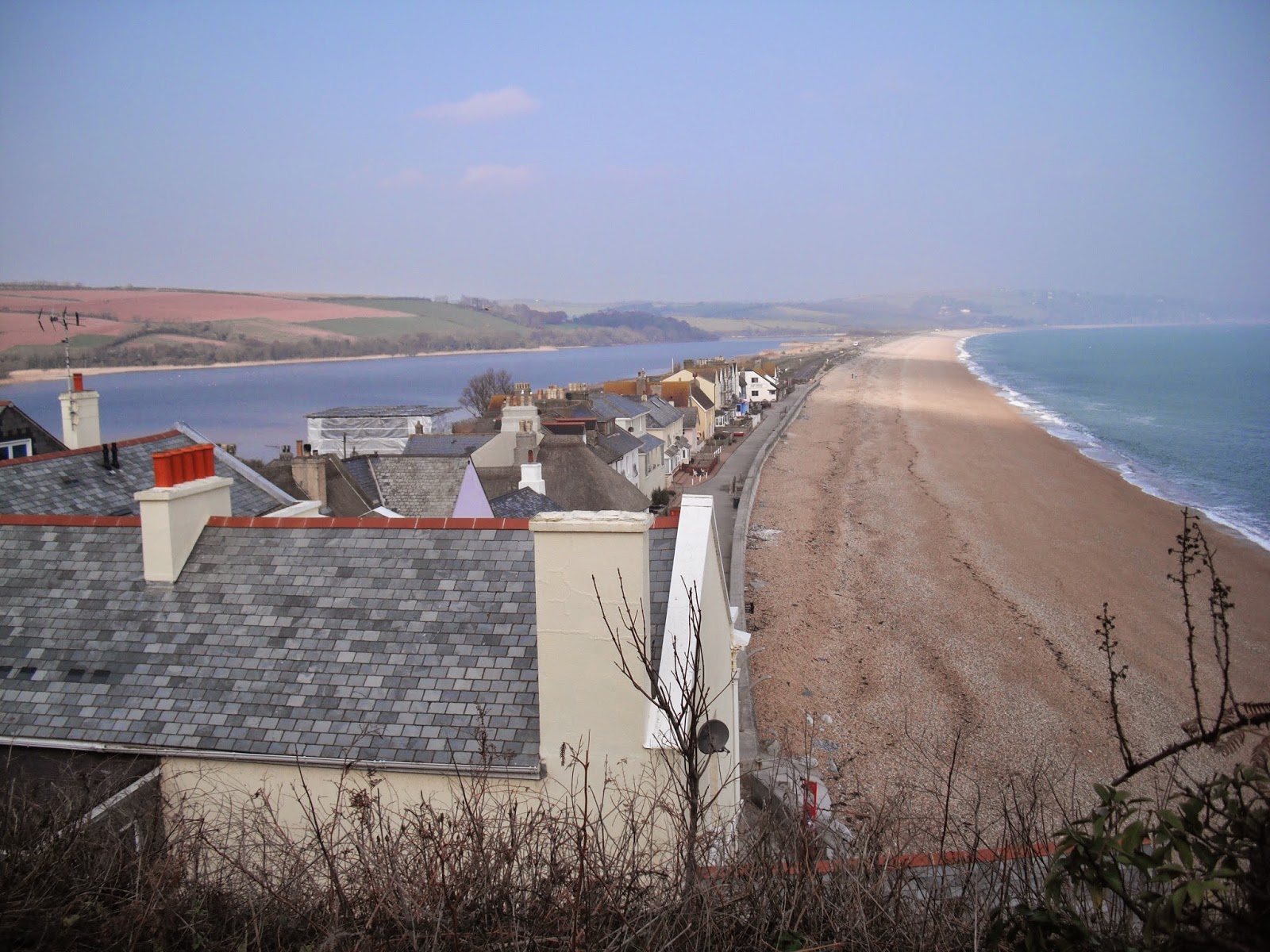
The rest of this walk is flat alongside Slapton Sands on one side and Slapton Ley on the other. The Ley is the largest freshwater lagoon in the south west. It is 1.5 miles long and is a national nature reserve of special scientific interest. The beach here is comprised of tiny red pebbles. This whole area is very vulnerable to erosion including the road which has been rebuilt in the last few years.

Look out for the obelisk which commemorates the area as a practice ground for American D Day forces in 1943. The villages (about 3000 people) near here were evacuated for these practices (including their livestock) for about 12 months. The obelisk memorial was presented by the USA authorities. Also watch out for the Sherman tank which was used in the practices – it was abandoned in the water and recovered and restored in the 1960s.

The walk finishes at Torcross.

Photos show: Slapton Ley and sands; The Square Lagoon, Dartmouth; Dartmouth Castle.


Wednesday, 25 March 2015

Walk 129 Brixham to Kingswear (Devon)

Walk 129 Brixham to Kingswear (Devon)

(Second leg of English coastal walk – Broadstairs to Lands End)

Map: L/R 202
Distance: 12 miles or 19km approx
Difficulty: challenging, some steep paths to the coves.
Terrain: mainly cliff coastal path
Access: Parking at both ends
Public transport: 18, 18A bus between the two towns.

Start the walk at Brixham Harbour. In the 1880s the town was the country’s leading fishery. Every year the town celebrates the old Brixham Trawlers (powerful fishing smacks) with a ‘sail’ race around Torbay.

At the inner harbour can be seen an impressive replica of the Golden Hind opened in 1963. It is very popular with tourists and is often used by schools as a learning resource. Look out for The Mayflower Garden near the quayside put together by locals as part of a Pride in Brixham event. A replica of The Mayflower (Mayflower 2) was built in Brixham and sailed to the USA in the 1950s.

Near here is Greville House which was built as an orphanage in 1813 as part of the Torbay and Dartmouth Mission. It provided for the sons of deceased British seamen and was last used as an orphanage in 1988. It was reopened by the charity in 1990 as an outdoor education centre.

Brixham earned a reputation for smuggling in the 18th century. In one famous incident contraband was transported in coffins during an outbreak of cholera. The town also played an important role during the D Day landings in 1944 when US troops destined for Utah beach embarked from here.

Continue the walk out of the town up to Berry Head which is part of a country park. The fort up here was built during the Napoleonic Wars of 1794 and 1804 and is on the site of an old Iron Age fort. Nearby is the lighthouse with a compass type guide naming the various views from this lookout point. Now for a bit of factual trivia. This lighthouse is the highest, shortest and deepest in England. Highest because no other lighthouse stands on a headland so high. Deepest because its 30 foot pit houses the clockwork weights by which it is driven. Shortest because the lens is just 6 feet above ground level. The lighthouse was built in 1906 and is now electrically operated.

Continue the walk around to St Mary's Bay which has a sand and shingle beach accessible only by footpath. The area around here, some owned by The National Trust, is a haven for rare species that depend on the thin limestone soils. These include the greater horseshoe bat which has been encouraged by introducing cattle. Cow pats are produced by the cattle, these in turn produce dung beetles which are food for the bats!

The walk continues with coves, remote beaches, rugged rocks and steep paths. Continue around Scabbacombe Head, soon the path turns inland alongside the estuary. Look out for the Mew Stone and the caves near it.

At Mill Bay Cove is Brownstone Battery which is one of the few surviving Second World War defence positions. Further buildings are hidden among the trees including gun and searchlight positions. It was built in 1940 to protect the Dart Estuary and was manned by 300 soldiers who watched for the invasion that never happened. It was decommissioned in 1950 and is now in the care of The National Trust. Look out for The Mill at Mill Bay Cove. This was a disused limekiln that was converted into a watermill and boathouse in the 19th century in the form of a 'castle'. Across the estuary is Dartmouth Castle.

The walk ends at Kingswear where there is a ferry to Dartmouth. The lower ferry slipway has been a landing place for a long time. In 1170 pilgrims from Brittany landed here en route to Canterbury. The TV series The Onedin Line and the film of The French Lieutenant's Woman were both partly filmed here. Look out for the wishing well built into the wall near the main ferry.

Highly recommended is a trip on the Dartmouth Steam Railway. This is unusual in that it is run as a business for profit not charity. The original line was opened in 1864 and sold by British Rail in 1973. It runs to Paignton and back, with stops on the way, and links with the Dartmouth Ferry. Pay extra for an observation carriage if you can.

Top photo shows: Replica of The Golden Hind at Brixham, Bottom one: Berry Head Lighthouse. 


Thursday, 26 February 2015

Walk 128 Torquay to Brixham (Devon)

Walk 128 Torquay to Brixham (Devon)

(Second leg of English coastal walk – Broadstairs to Lands End)

Map: L/R 202
Distance: 11 miles or 16 km approx
Difficulty: moderate
Terrain: road, pavement and coastal path
Access: Parking at both ends
Public transport: 12 bus from Torquay Harbour goes frequently between the two towns.

Follow the seafront in Torquay to The Princes Pier. This was built between 1890-1906 and once had an entertainment complex at the end. Torquay looks out on to Tor Bay – the British fleet was anchored here during the war with France. Officers wives and families came to live in the town and hastened its development.

I found Torquay to be a most welcoming place even though holiday makers are known in these parts as ‘grockles’ ( not sure exactly what it means but it doesn’t sound too complimentary). Look out for the palm trees flourishing here helping to give the area the title ‘The English Riviera’.

Torquay Pavilion, once called The Palace of Pleasures, is near the attractive promenade gardens. Look out for the memorial of Agatha Christie – the museum further back in the town is well worth a visit if you want to find out more about her strong connection with Torquay. Follow the walk around to Torre Abbey Sands then Corlyn’s Beach. Torre Abbey, which is back from the seafront, is a mainly 18th century house with art gallery and museum. It also has a 14th century gatehouse and 12th century barn where Spanish Armada prisoners were locked up.

Take a time to look back at the main part of Torquay. The white buildings have been likened to the layers of a wedding cake. On the way out of Torquay is a small beach called Institute Beach but I can’t find an explanation for this name. The walk from here is on the main road before rejoining the beach road after Hollicombe.

Continue round to the beach huts at Preston Sands and a view to Paignton ahead. As you approach Paignton Sands – the pink sands appear to turn redder as the tide comes in. Paignton developed quickly as a resort when the Torbay and Dartmouth railway opened to passengers in 1859. There is more about this steam railway, now run by volunteers, in the next walk.

Alongside the promenade at Paignton is a huge grassed area providing a great space for people when the tide comes in. On the way out of Paignton is a colourful terrace of holiday accommodation. To the south of Paignton is the 780 ft. long pier built in 1879. The pavilion at the end was famous for performing Gilbert and Sullivan with the original D’Oyly Carte Company. The pier head was used as a defence during the Second World War. It was revived in 1980 and has thrived since then.

Look out for the impressive Paignton Club at the end of the promenade. This building with its Doric columns was built as a Gentleman’s Club in 1884. Women play more of a part these days! Continue the walk around to Paignton Harbour. Established in the 18th century this was once a thriving fishing port. Now there is a mixture of uses including leisure and fishing trips. The viewing platform which overlooks the harbour is a good place for a rest.

Walking up and out of Paignton look out for Oldbury Mansion, this was built by the sewing machine king, Issac Singer – the building is said to be modelled on Versailles. Further round is Fairy Cove which is a popular little bay with families. Follow the walk around Roundham Head and down to Goodrington Sands. The coastline here alternates between bay and headland. This is mainly because of the difference between hard Devonian limestone resistant to the sea and the softer red sandstone which erodes easily.

The path around Saltern Cove has been diverted to follow the rail line – if you are lucky a steam engine may appear. The walk from here around Broadsands and Elberry Cove is pleasant enough. Fishcombe Cove is a secluded place accessible only by a steep path and is just outside Brixham. On the way from here into Brixham I was stopped by a man who wanted me to visit his free tank museum. I felt a bit guilty about saying no but needed to catch a bus back from Brixham.

Brixham is the final part of Torbay. Look out for the statue of William of Orange who landed here in 1688 to begin The Glorious Revolution. There are many, many boats in the harbour reflecting the fact that Brixham was the country’s leading fishery in the 1880s. More about Brixham in the next walk.

Photos show promenade gardens, Torquay; Institute Beach, Paignton; The Paignton Club; Fishcombe Cove near Brixham


Wednesday, 21 January 2015

Walk 127 Teignmouth to Torquay (Devon)

Walk 127 Teignmouth to Torquay (Devon)

(Second leg of English coastal walk – Broadstairs to Lands End)

Map: L/R 192/202
Distance: 14 miles or 20 km approx
Difficulty: moderate, challenging in parts – allow all day to complete.
Terrain: mainly cliff coastal path
Access: Parking at both ends
Public transport: Rail links at Torquay and Teignmouth. Check the Shaldon Ferry is running.

Start in Teignmouth and walk to take the Shaldon Ferry. This small ferry runs all year, subject to weather conditions, and is reckoned to be the oldest working ferry in the country. 

On arrival on the beach at Shaldon look back for a good view of Teignmouth and upstream to the Shaldon road bridge. Follow the road, then the footpath, to The Ness which is a wooded headland planted to celebrate Queen Victoria’s silver jubilee in 1863. On this walk there are a number of old World War 2 defences. At the top of The Ness are panoramic views back up the coast and inland.

The path from here to Oddicombe (passing Maidencombe and Watcombe Head) is a bit of an upper and downer and I found it rather tiring. Quite a bit of the walk is away from views of the coast which is a bit disappointing.

Look out for Oddicombe Beach with its red cliff face and the funicular railway that runs from beach to cliff top. This was built in 1926 and is one of 16 funicular railways still operating in the UK. They are cable operated with the descending and ascending vehicles counterbalancing each other.

The next feature is Babbacombe Harbour, a picturesque spot which has a well known model village set back from the cliff top. Look out for the waterfall which flows down to beach level.

A short walk further along and just on the north of Torquay is Anstey’s Cove. It has a sheltered beach with blue water (on the day I went this was quite distinctive). It is celebrated in verse within the poem ‘Beautiful Torquay’. Unfortunately, it was written by William McGonagall reckoned by many to be the worst poet in the English language.

Soon, past Anstey’s Cove, is Black Head; to the south Hope’s Nose is visible across the bay. The rocky limestone landscape here was created by volcanic activity millions of years ago – the formations and layers can be clearly seen. Geological evidence shows that this area used to be 10 degrees south of the equator. The mind boggles.

After walking round Hopes Nose, Thatcher’s Rock becomes visible. It has a raised beach 8 metres above today’s sea level. It was formed in the ice age.

About a mile further along is Meadfoot Beach. This is known as the ‘local’s’ beach as it is away from the busy main beaches of Torquay. Overlooking the shingle beach and 6 acres of landscaped grounds is The Osborne Hotel which takes up the centre part of the Regency Crescent. It was completed in 1848 and has 32 luxury bedrooms.

Soon after Daddyhole Cove is the start of the Rock End Walk leading into Torquay. It follows a limestone wall towards a castellated summer house. This is all that remains of the estate of Rock End, a large Victorian House.

Torquay is second only to Blackpool as the country’s leading holiday destination. It’s growth stems from the Napoleonic Wars when the richer classes were forced to look closer to home for their relaxation. Follow the path, then road, to the Marina which is not far from Torquay Station.

Photos show: Shaldon Ferry; Shaldon Beach; The Ness at Shaldon; Oddicombe Beach; Waterfall at Babbacombe beach; Anstey's Cove 


Sunday, 4 January 2015

Walk 126 Starcross to Teignmouth (Devon)

Walk 126 Starcross to Teignnouth (Devon)

(Second leg of English coastal walk – Broadstairs to Lands End)

Map: L/R 192
Distance: 10 miles or 15 km approx
Difficulty: fairly easy
Terrain: road and coastal/river path
Access: Parking at both ends
Public transport: Regular trains from Exeter St Davids in both directions

A very, enjoyable walk on a fine day – at other times, as it is very exposed, it could be unpleasant which would be a shame.

From Starcross, follow the path, then the road southwards, to Cockwood. This is a picturesque tidal harbour. The path is actually pavement all the way to Dawlish Warren – it is also alongside the main south west railway line from Paddington.

Dawlish Warren, seemed to me, to be a rather odd mixture of caravans, holiday parks, amusements and a nature reserve. The beach and reserve are attractive enough, although, despite being a warm September day, both were deserted. There were plenty of people around the other attractions.

The town of Dawlish is a mile or so further south. The path runs alongside the seaward side of the railway before crossing into the town. It passes the distinctive red cliffs and it is not hard to imagine how vulnerable the line is to the sea during rough weather conditions. It was wrecked during the storms and high winds of 2014. Originally, the line was going to run further away from the cliffs but this would have meant cutting across corners. Isambard Kingdom Brunel was busy blasting five tunnels in nearby rocks and some of these tunnels can be seen on the walk. A local author reckoned that Dawlish is probably the only town in England that has its railway station on the seafront and town centre at the same time. In 1765 Dawlish appeared on maps as a fishing village, then sea bathing became very fashionable after George 111 used it for improving his health leading to its development as a resort.

The path continues to Coryton’s Cove which is only a short distance from Dawlish. The red sandstone here was formed 250 million years ago when the area was a vast arid desert surrounded by older mountains. The red iron oxide cements the sand grains together. This cove has one of the most sheltered beaches on this stretch of coast as it is exposed to only easterly winds. At the time when bathing was segregated it was reserved for gentlemen’s bathing. Above the cove is Lea Mount with good views back to Dawlish.

Continue to Holcombe where, after a diversion inland, the coast is rejoined at the point where the railway line appears out of one of Brunel’s famous tunnels. Take time to look back at the red cliffs and Shag Rock poking out of the sea.

The final destination on this walk is Teignmouth (pronounced ‘tinmouth’, I learnt to my embarrassment) - another pleasant place to rest and admire the sea views. The town has suffered in wars and was burnt down in 1690 during a French raid. The poet Keats must have appreciated the place as he brought his ailing brother Tom to the town. The father of computing Charles Babbage (1791-1871) was  a resident here.The pier was built in 1865 and was originally 700 feet long with provision for concerts and dances; it still has arcades, rides and children’s entertainment. From the harbour, granite was shipped to build the old London Bridge. The town originally developed around the old Saxon church of St Michael. Fishermen’s cottages and salterns (seawater pools) and salt huts for processing salt were once here. Various trading activities date back to the 13th century and the port still handles clay, timber and grain. A lot of ship building has also taken place in the area. During the Napoleonic Wars 68 vessels were built and in World War 2 around 100 were built for The Admiralty.

Walk to the estuary of the River Teign. The river runs about 60 miles from its source in the peaty bogs of Dartmoor. From the harbour, the small lighthouse can be seen. It was built in 1846 to guide ships into the harbour entrance. On the stroll around this area look out for some of the modern sculptures which adorn the front. Inland, the road bridge can be seen but this is a very along walk around. Fortunately, The Shaldon Ferry is available to take you to the other side for the start of the next walk.

Photos show: Coryton's Cove; rail tunnels and walk alongside rail line near Holcombe; Teignmouth front and pier; River Teign looking inland to road bridge.


Thursday, 11 December 2014

Walk 125 Exeter to Starcross (Devon)

Walk 125 Exeter to Starcross (Devon)

(Second leg of English coastal walk – Broadstairs to Lands End)

Map: L/R 192
Distance: 12 miles or 18 km approx
Difficulty: fairly easy
Terrain: road and coastal/river path
Access: Parking at both ends
Public transport: Regular trains from Exeter St Davids in both directions

It is worth spending a few hours or more in Exeter including the 14th century cathedral which was badly damaged in World War 2 and the Roman walls which go around the city.

From St David’s Station cross the River Exe at the first crossing point. In the thirteenth century a weir was built here by the Countess of Devon and this blocked the port. However, a lawsuit was decided in favour of the Exeter citizens and the weir was removed. Unfortunately, the river had silted up making navigation impossible. As a result Exeter Canal was completed in 1566 by engineer John Trew. The northern end of the canal can be seen a little further along the walk.

Continue alongside the river to the quayside. You don't need to use it but it was 30p to get the ferry to the other side when I went – there are some attractive outdoor eating/drinking places and an 18th century custom’s house on the quayside.

Further along is the canal basin. This was the last extension to the Exeter Ship Canal built in 1830. It provided reliable deep berths in the heart of the city for large sea going vessels. This helped to increase trade and contribute to Exeter’s wealth. The canal is over 5 miles long and goes alongside the River Exe. A huge variety of goods passed along the canal but the amount started to decline when the railways came in 1844.

Continue along the path to the Kings Arms sluice and Trew’s Weir. A double lock beyond here allows two vessels to park side by side, which is an unusual feature. Beyond this is the site of old lime kilns on the opposite bank. The limestone came mainly from Torbay and Plymouth and the high temperatures in the kilns produced quicklime – this was spread on the land to improve the soil and for speeding up the decomposition of bodies after burials.

The Turf Canal Basin further south allowed vessels to wait for a suitable tide, wait for fair weather or transfer goods between sea craft. Ships sailed to here from as far away as the West Indies. The Turf Lock Hotel which is still here would have been a busy cosmopolitan place. Look out for the old cottage, a small dwelling for the lock keeper – it is very near to the waterside. From here you can see Topsham on the opposite bank. Soon after this the canal merges with the River Exe.

About a mile along the river are the grounds of Powderham Castle. The building, which is the home of the Earl of Devon can be seen on the hilltop.

This part of the walk ends at Starcross. A ferry runs from here to Exmouth on the opposite bank of the river. Look out for The Atmospheric Railway pub on the seafront road. This is named after the Brunel built railway (this still runs from along this coast from Paddington to Penzance) which was originally designed as a revolutionary ‘atmospheric railway’. Two pump houses drew air out of a pipe between the rails and this produced a vacuum which worked a piston that in turn propelled the trains. The effects of the weather, rats and mice jamming the pistons (they ate the grease of the leather air tight seals) meant horses then had to be used to pull the trains. All this meant the expensive experiment ended in 1848 and steam then diesel (still diesel) took over.     

Photos show: Butt Ferry at Exeter Quayside; River Exe with Exeter on the opposite bank; Lock-keeper's cottage; Atmospheric Railway Pub at Starcross. 


Wednesday, 19 November 2014

Walk 124 Budleigh Salterton to Lympstone, Exton, Topsham, A La Ronde

Walk 124 Budleigh Salterton to Lympstone with visits to Exton and Topsham and suggested trip to A La Ronde (Devon)

(Second leg of English coastal walk – Broadstairs to Lands End)

Map: L/R 192
Distance: 11 miles or 17kmm approx  (includes walks around Exton and Topsham)
Difficulty: moderate
Terrain: cliff paths, road and lower coastal paths
Access: Parking at both ends
Public transport: Bus 157 goes hourly between Budleigh and Exmouth, a train leaves hourly for Lympstone from Exmouth Station

Leave Budleigh Salterton by climbing up the coastal path on to the cliffs of West Down. From here there is a good view of Littleham Cove and Otter Cove with their distinctive red rocks. When I walked along here there was sporadic gun fire from the military range at Straight Point – the path must be strictly kept to and danger avoided. To the right is a huge caravan site of over 2000 units. The estuary of the River Exe can be seen in the distance.

Continue along the cliffs above Sandy Bay and down on to the road which leads in to Exmouth. Walk past the lifeboat station and to The Point then navigate along the roads to the main sands (Exmouth rail station is near here). The town was a fishing village from pre Roman times and be the end of the 12th century was one of Devon’s main ports. The town became a popular resort in the mid 18th century when many fine Georgian houses were built. The front is quite attractive with its distinctive clock-tower and wide sands (when the tide is out).

Follow the coastal path out of Exmouth and continue to Lympstone. This is a small attractive coastal village. To the north of Lympstone are the Lympstone Barracks – which house the Royal Marines.

The next two points can be reached by rail or car. Walking is possible but involves a tedious trudge along various roads inland.

Exton is on the single track rail line from Exmouth to Exeter. The mudflats, sandbanks and marshland of the estuary of the Exe are of international importance and provide thousands of habitats for birds and other wildlife.

At Topsham look out for the houses that have been converted from old storehouses and sail lofts. These date from the town/village’s heyday as a major British port and shipbuilding centre. There are several Dutch style buildings – these stem from the wool and cotton exported from here – Dutch bricks acting as ballast in the ships were brought in on the return journey.  The shop on the high street has a mural which reflects Topsham’s past.  The museum has interesting information about  Topsham including a section on the actress Vivien Leigh. Her connection with the village is through her one time husband Leigh Holman whose sister lived in the house which is now the museum. She founded the museum and made several donations connected with the actress.


Close to Lympstone is the unique building ‘A La Ronde’ owned by the National Trust. This 16 sided house, once owned by two spinsters, is well worth a visit. On their return from a grand tour of Europe in the late 18th century the ladies designed this unique building and included a shell gallery, feather frieze and other idiosyncrasies. This is best visited by car.

Photos show: Littleham, Otter Coves and Straight Point; Sands at Exmouth; Exmouth front and clock tower; single track railway line near Exton; Topsham; A La Ronde.