Total Pageviews

Sunday 28 April 2013

Walk 94 Bosham to Southbourne (West Sussex)


 Walk  94   Bosham to Southbourne (West Sussex)

(Second leg of English coastal walk – Broadstairs to Lands End)

Map: L/R 197
Distance: about 8 miles or 13 km.
Difficulty: Easy
Terrain: Mainly footpaths, some pavements
Access: Parking at both ends
Public transport: 55A Bosham to Chichester every hour or so Mon-Sat (a few on Sundays). Rail link to Chichester at Southbourne

There is not too much to write about this quiet and pleasant walk.


Follow the path to the north out of Bosham until it meets the A259. Walk west along this road (which follows the route of the old Roman road) and turn down the footpath that leads to Chidham.

This village, which is a little inland from the coastal path, has been occupied for more than 4000 years (recent finds have confirmed this). The name Chidham is derived from ‘ceod’ (meaning bag or pouch) and ‘ham’ (meaning settlement) – it refers to the shape of the peninsula. St Mary’s Church, Chidham was built in the 13th century.

On the walk around the peninsula a number of flood defences can be seen including piles of rocks in fields. Cobnor Point is at the southern most tip and there are good views across Chichester Channel to the West Itchenor area.

On the walk northwards is Chidham Point which provides good views of Thorney Island opposite. Around here is the Nutbourne Marshes Nature Reserve – a saltmarsh which is an important habitat for wildfowl and waders.

Follow the path round into the now expanding village of Southbourne.

Snaps show sea defence in a field; a caravan at Chidham; view from Cobnor Point; view from Chidham Point.


Monday 8 April 2013

Walk 93 East Wittering to Bosham


 Walk  93   East Wittering to Bosham (West Sussex)

(Second leg of English coastal walk – Broadstairs to Lands End)

Map: L/R 197
Distance: 11 miles or 16km approx.
Difficulty: Fairly easy – stony beach walking can be tiring
Terrain: Paths, pavements, beach  
Access: Parking at both ends
Public transport: 52/53 frequent service from Chichester to East Wittering Mon – Sat (once and hour on Sunday). 55A Bosham to Chichester every hour or so Mon-Sat (a few on Sundays).

This walk can only be done between mid May until the end of September as it involves using the West Itchenor ferry.

The first part of the walk from East Wittering/Bracklesham Bay is along the pebbly beach. A very large caravan park is on the eastern side with some interesting modern houses overlooking the beach. Portsmouth and the Isle of Wight are usually visible from here. The beach was used by Canadian forces to practise for D Day in 1944. Now it is very popular with surfers.

Continue the walk on the path alongside the sandy shoreline to the entrance to Chichester Harbour. Some of the houses along this stretch have their own beach gardens. There is a choice at the end of this path either take a walk around East Beach or turn right and continue past West Wittering. The sandy dunes along here make it a pleasant spot to sit and rest. Much of the area is managed by The National Trust and it has a range of wildlife specific to the conditions.

The walk continues past West Wittering through an area called Snowhill (no snow, no hill). Carry on to West Itchenor, a village which appears to be dominated by the sailing community. Catch the seasonal ferry from here to Smugglers Lane on the other side. As the name suggests there was a lot of smuggling in the area especially the sending of brandy into Chichester. The ferry dates back to the 17th century and, following a period when it was out of use it was reinstated in 1976.

Follow the path into Bosham which is a very attractive place. When the tide is in it covers the road and you can see how houses have been specially adapted to cope with this. If the tide is out there is an extraordinary, picturesque stretch of green algae instead of the water.

The village goes back to Saxon times. Legend tells of a Danish raid in which the church bells were stolen. The Danish ship sank in the channel and the lost bells are said to ring in answer to the present bells. It was at Bosham that King Canute supposedly tried to turn back the waves (other places make this claim as well) – legend also has it that his young daughter was drowned in a millstream nearby and was buried in the church. In 1865 an excavation found the bones of a girl about 8 years old so maybe it is true. Bosham Church is depicted in the Bayeux Tapestry showing King Harold going in there to pray for safe passage to Normandy in 1064.

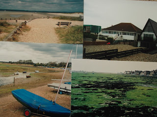
Snaps show: East Head, Chichester Harbour; buildings on the beach Brackleshem Bay; Snow Hill; Bosham.