Total Pageviews

Wednesday, 30 March 2016

Walk 174 Barnstaple/Braunton to Woolacombe (Devon)

Walk 174 Barnstaple/Braunton to Woolacombe (Devon)

(Third leg of English coastal walk – Lands End to Bristol)

Map: L/R 180
Distance: (30km/21 miles from Barnstaple) 20km or 13 miles from Braunton
Difficulty: quite easy/moderate
Terrain: coastal path, some sand dunes
Access: Parking at both ends.
Public transport: 303 bus runs between all three places but only a few go straight through – check with Traveline website.

I decided to get the bus to Braunton and walk from there to Woolacombe. It is perfectly possible to walk from Barnstaple, alongside the River Taw before cutting inland towards Braunton. Just seemed rather a long way for not much gain as far as the coast is concerned.

The path (also a part of the Tarka Trial) out of Braunton goes alongside the marsh, around Horsey Island then parallel with Braunton Burrows and Saunton Sands. Be careful here as I came across several members of the army with machine guns who politely but firmly pointed out the way I should go! Look out for any military 'danger area' notices as well. The sand dunes on the burrows are some of the most protected and treasured environments in the UK with 33 species of butterflies and 470 species of flowering plants.

It feels like a long walk through the Burrows and on to Croyde Bay - another place popular with surfers that has potentially dangerous tides. Near to the path at Croyde is a notice erected by The National Trust; it is alongside some old whale bones which are the only remains of a whale washed up here in 1915.

The path goes around Baggy Point which is now managed by The National Trust. There is evidence of 7000 years of human activity in this area including medieval farms, D Day troop manoeuvres and shipwrecks, including HMS Weazle that met its end with the loss of 105 lives. The head is riddled with caves, and seals can be seen basking on the rocks. Lookout for the Coastguard Training Pole (seen better days) which dates back to 1930. The National Trust, as part of a heritage year in 2015, were seeking to replace it. Coastguards fired rescue lines tied to the post to a ship in trouble and people would be rescued one by one on a breeches buoy.

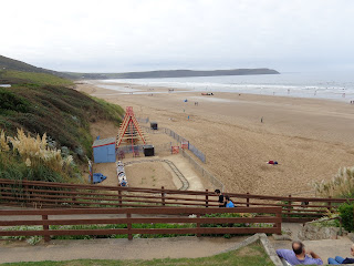
Coming away from Baggy Point the path continues alongside the two miles of surfing beaches at Woolacombe Sand and into Woolacombe. The town expanded in the middle of the 19th century when it became popular with tourists. The beach here was used by American troops to train for the D Day landings. They set up their local HQ at the Woolacombe Bay Hotel.

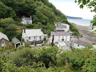
Photos show: Braunton Burrows and Saunton Sands; Woolacombe Sand looking to Baggy Point.


Monday, 21 March 2016

Walk 173 Bideford to Barnstaple (Devon)

Walk 173 Bideford to Barnstaple (Devon)

(Third leg of English coastal walk – Lands End to Bristol)

Map: L/R 180
Distance: 12 miles or 20 km approx
Difficulty: quite easy
Terrain: mainly coastal and riverside path
Access: Parking at both ends.
Public transport: Frequent buses between Bideford and Barnstaple

Cross the River Torridge in Bideford using the old bridge which dates back to the 16th century. Evidently, not one of the 24 arches is the same size! On the other side is the aptly named East the Water where the path crosses the road but soon returns to the riverside. On the walk up the Torridge there is at least one rusty, abandoned hulk. Dominating the view is the A39 bridge which is rather pretentiously called The Atlantic Highway. A rather odd, small MOD property appears to contain a number of stuffed toys clinging to the inside of the wire fence.

Soon, the rather attractive front at Instow appears in view. For railway buffs this is a place to savour some old signals, signal box, platform and crossing gates. The meadow here is especially planted to provide interesting plants all year round. Continue the walk out of Instow alongside the north beach. There is a great little shop in Instow which provides interesting food and local produce.

After a few further miles you arrive at Lower Yelland and Home Marsh Farm. This section of the path is part of the Tarka Trail – a 150 mile figure of eight walking route. It is named after Henry Williamson's book Tarka the Otter which is set in the surrounding countryside. In the 1940s the area around Home Farm Marsh was one of the many wetlands drained to make the land more viable for agriculture. However, this was at the price of plant species and visiting birds whose numbers were greatly reduced. It was acquired by the Gaia Trust in 2002 who returned it to its original state. If you have time you can wander around the area and reflect the trust's motto which is “People and nature together since 1988”.

Across the River Taw is Horsey Island. Along the stretch between Lower Yelland and Fremington Quay the path follows what was once a railway line. Steam trains from Barnstaple ran along here for many years, to allow coal and lime to be imported from Wales and local pottery to be exported. The line was finally closed in 1982. For more information about the area, and the railway, Fremington Quay Heritage Centre is situated next to a cafe whose premises are in the old station.

Continue the walk around to the bridge which takes you into the main part of Barnstaple. Over the bridge is the clock tower and Barnstaple Museum which is well worth a visit.

The town, one of the oldest in Britain, has been a royal borough since 930 and is one of only 4 Devon boroughs in the Domesday Book. Its importance as a port diminished when the River Taw silted up but it is still a major regional centre.

A few of the landmarks I enjoyed looking at here are: Barnstaple Parish Church of St Peter and St Mary – in 1864 Gilbert Scott was asked to straighten the crooked spire but refused as he said it was distinctive – look for the info boards which tell the story of two interesting vicars; Church Lane and its surroundings where almhouses were provided for the poor by prosperous 17th century merchants were built (together with the Alice Howard School for young maids); The Royal and Fortescue Hotel with its impressive frontage, formerly a coaching inn, it got its 'Royal' name from after the former Prince of Wales enjoyed apple pie and ice cream here in 1856.

Photos show: the old railway signals, box, gates etc. at Instow; Fremington Quay; Royal and Fortescue Hotel in Barnstaple. 


Sunday, 13 March 2016

Walk 172 Westward Ho! to Bideford (Devon)

Walk 172 Westward Ho! To Bideford (Devon)

(Third leg of English coastal walk – Lands End to Bristol)

Map: L/R 180
Distance: 8 miles or 14 km approx
Difficulty: quite easy
Terrain: coastal path and road
Access: Parking at both ends.
Public transport: Frequent buses between Bideford and Westward Ho!

Follow the promenade out of Westward Ho! and then the track alongside Northiam Country Park and golf course. Much of the country park is salt marsh some of which is unaffected by tides allowing sheep and horses to graze. Cockles, mussels and clams attract wading birds including curlews, oyster catchers and egrets. Brent geese also spend the winter here. The pebble ridge which extends along this bit of coastline has been caused naturally by the waves. Out at sea are 22 turbines belonging to the Fullabrook Wind Farm.

Follow the path around the coast alongside where the River Taw and River Torridge meet and on to Appledore. There is a pleasant promenade here which faces the bank opposite. Appledore has always been a sea faring place, for example in 1580 15 vessels and 115 mariners were based here. Local salmon fishermen have also landed their catches for many years. The bed of the estuary is home to some animals with special features. These include the tiny pea crab that lives inside mussel shells and various worms and snails.

On the way out of Appledore is a quay and dry dock. The latter was big enough to hold two large vessels and was badly needed in Napoleonic times to build and repair ships. Associated trades such as chandlery and sail and rope making helped to make the village very prosperous. It was also used in World War 2 when landing craft, motor gunboats and mine sweepers were needed.

Follow the walk down the River Torridge, under the A39 bridge and into Bideford. As you walk in, look out for the Charles Kingsely statue marking his association with the area especially Westward Ho! and Clovelly. The main street into the town is also the quayside. In the 16th century, during the time of local man Sir Richard Greville, Bideford was Britain's third port. He mounted his expedition to the Americas from here and most of his crewmen were from Bideford. On one expedition, to North America he brought home a red Indian servant whom he christened Raleigh. The servant died after a year and is buried in Bideford churchyard.

Further along the quay is the 16th century Kings Arms, the only pub left along the quayside. With its many original beams, this is a good place to break for refreshments.

Before leaving Bideford, do not miss the sombre plaque on the side of the town hall. 'In memory of Temperance Lloyd, Susannah Edwards and Mary Trembles all of Bideford hanged in 1682, the last to be executed in England for the crime of witchcraft'.

Photos: Appledore; The Kings Arms, Bideford.


Tuesday, 8 March 2016

Walk 171 Clovelly to Westward Ho! (Devon)

Walk 171 Clovelly to Westward Ho! (Devon)

(Third leg of English coastal walk – Lands End to Bristol)

Map: L/R 190 and L/R 180
Distance: 12 miles or 21km approx.
Difficulty: Demanding for the most part
Terrain: Coastal cliff path and road
Access: Parking at both ends.
Public transport: Both Westward Ho! and Clovelly are accessible from Bideford by bus but here is no direct bus link between the two.

This walk is book ended by two easier sections but don't be fooled, the middle bit is strenuous. In fact, I found a fellow walker fast asleep by a stile after the difficult section! (Yes, he was asleep, I saw him in the pub later).

Follow the coastal path at the top of Clovelly along Hobby Drive. The building of this road provided employment for out of work fishermen and French Prisoners of War. According to a concrete seat at the road side it was completed in 1901.

Further along, the gaps between the trees provide some good views including one of Bucks Mills. The stream that runs through the village powered at least one mill here. Originally, there was a quay for local fishermen. In the 18th and 19th centuries many of the residents were related to the Braund family one of whom, Captain James Braund, became known as King of the Bucks. The original inhabitants of the village gained a reputation for their dark looks and for keeping to themselves. It is thought that they descended from survivors of a Spanish shipwreck in the 15th century. I've just bored my plumber, also called James Braund, with this story.

The path goes along the high, craggy cliffs at Peppercombe. There was supposed to have been an ancient castle here and this is marked on the OS map. Also near to Peppercombe Castle is a place called Giffard's Jump, named after a young man on a picnic party who while sitting fell backwards over the edge, dropped a 130 ft on to the rocks but sustained no injury!

Continue along to Babbacombe Cliff and towards the outskirts of Westward Ho! There is clearly much of geological interest in the cliffs judging by the large amount of students I saw donning yellow hats.

The path come out on to a road into Westward Ho! and a much needed respite from the hills. Nice enough sea front but don't expect anything quaint to match the town's name. Victorian property developers took the name from Charles Kingsley's novel of Elizabethan sailors. The area was a boyhood haunt of the book's hero. However, it is reported that the author was not a supporter of the building project. There was once a 500 ft pier here but with a number of other buildings it was washed away. Westward Ho! has the distinction of being the only town in the UK with an exclamation mark.

Another literary connection is with Rudyard Kipling. Kipling Terrace in the town was formerly the United Services College which the author attended between 1878 and 1882. He based the writing of Stalky and Co on his experiences here.

Photos show: Bucks Mills; Westward Ho! front.


Thursday, 3 March 2016

Walk 170 Hartland Quay to Clovelly (Devon)

Walk 170 Hartland Quay to Clovelly (Devon)

(Third leg of English coastal walk – Lands End to Bristol)

Map: L/R 190
Distance: 12 miles or 18km approx
Difficulty: Demanding, allow plenty of time – lots of ups and downs and some are very steep.
Terrain: Coastal cliff path
Access: Parking at both ends.
Public transport: Not practical to get to Hartland Quay using public transport. Clovelly is served by a bus service from Bideford a few times a day check with Traveline.

Another murky morning for me, so no photo opportunities not until past Hartland Point. This stretch is known as the 'wrecking coast' for obvious reasons. The walk out of Hartland Quay starts off easily enough but soon becomes challenging. Alongside the path at The Warren is an old ruin of a tower which is reportedly a 16th century folly - possibly used as a warrener's house (person in charge of a rabbit warren).

Follow the path around to Dyer's Lookout and across the Abbey River (named after the 12th century Hartland Abbey half a mile or so inland). Continue past the small rocky cove of Blackpool (no bright lights here) and along Upright Cliff, where this a waterfall, then on to Hartland Point. This 325 ft high headland was called 'Promontory of Hercules' by Ptolemy, the Greek astronomer and geographer. It was windy when I went, the waves were big and crashing in - I do not recommend going here in bad weather. The now automated lighthouse on rocks at the tip of the point was built in 1874 and has a strong beam.

The path now goes eastwards past Barley Bay. The strange looking object that looks a bit like a scoop of ice cream on top of a stick of rock is a radar tower. Further round near Titchberry is Shipload Bay. The name may refer to the smuggling that went on here – access to the beach looks very difficult.

A few miles further on is Beckland Bay. Look out for the memorial which marks the point where a Wellington bomber crashed in World War 2 with loss of all crew. The walk passes through woodland before reaching Clovelly.

Be sure you have your credit card or cash with you as entrance to the village (at least during the day) is via the visitors' centre at the top of the hill. I found the descent on the cobbles quite painful on the knees after a long walk. Fortunately there is a pleasant pub called The New Inn half way down for recharging the body. I saw several people pulling luggage down the cobbles on home made sledges. No cars are allowed in most parts of the village although a Land Rover service operates from the visitor centre down to the Red Lion on the quayside.

Clovelly was a small fishing village until the Victorians 'discovered' it. It is still overwhelmed with visitors and the entrance money goes towards maintaining the old buildings etc. From the top the harbour is a most impressive sight.

Photos show: typical view of headland and cliffs on this walk; transport over the cobbles in Clovelly; Clovelly, a view of the harbour from the top of the village.


Tuesday, 1 March 2016

Walk 169 Morwenstow (Cornwall) to Hartland Quay (Devon)

Walk 169 Morwenstow (Cornwall) to Hartland Quay (Devon)

(Third leg of English coastal walk – Lands End to Bristol)

Map: L/R 190
Distance: 10 miles or 16km
Difficulty: Demanding and challenging, allow plenty of time
Terrain: Coastal cliff path
Access: Parking at both ends.
Public transport: Not practical to get to Hartland Quay using public transport. Possible to get buses to Hartland but this involves a few miles walk inland after what is already a tiring walk.

I walked much of this in murky, damp weather which spoilt the views. I have heard, these are spectacular but the wet underfoot conditions made the downward slopes a bit worrying for slip hazards. Not far along the path from Morwenstow is the towering Henna Cliff one of the highest sheer cliffs in England.

When passing alongside the lonely rocky beach of Marsland mouth the border between Cornwall and Devon is crossed. A short distance further on is Welcombe Mouth. The valley near here was the haunt of a Danish sea captain called Coppinger, sole survivor of an 18th century wreck near Hartland Point (to the north of here). He later turned smuggler and wrecker and became known as 'Cruel Coppinger'.

Continue along the cliff tops for a few miles before arriving at Speke's Hill Mouth. Here, a waterfall pours down over the rocks into the cove.

The walk ends at Hartland Quay and for me, thankfully, the misty rain started to clear. This is an interesting little place with a small museum (opposite the hotel) which is well worth a visit. The history of the area is chronicled, including the high number of shipwrecks. One, in 1983, became infamous when a ship called the Johanna was stripped of its cargo by 200 people, some from as far away as The Midlands. Welcome refreshments are available near the museum.

Hartland Quay was known to have been a port and smuggling area from the 17th century. The port dealt in such things as coal, agricultural supplies and fancy goods. A local limekiln enabled burnt limestone to be used on the fields and produce bumper corn harvests for export out of the port. For a while, in the 18th and 19th centuries, there was a Hartland Quay Bank which produced its own currency notes. Hartland remained a port until the late 19th century but trade was in decline and there was not enough money to sustain costs and repair the pier.

The hill up to the car park provides some panoramic views of the coast.

Photos show: rocks to the west of Hartland Quay; the main street with hotel and museum at Hartland Quay.