Total Pageviews

Tuesday, 15 September 2015

Walk 141 Fowey to St Austell (Cornwall)

Walk 141 Fowey St Austell (Cornwall)

(Second leg of English coastal walk – Broadstairs to Lands End)

Map: L/R 204
Distance: 11 miles or 17 km approx
Difficulty: moderate, demanding in parts
Terrain: coastal and cliff path
Access: Parking at both ends
Public transport: Regular buses between the two towns and good rail links at St Austell.

On the quayside in Fowey is The King of Prussia Inn which was built in 1570 and was the home of John Rashleigh who sailed with Raleigh and Drake in his own ship. Follow the walk alongside the river estuary out of Fowey. Look out for the plaque marking the fact that the US naval advanced amphibious force was based here during 1943 and 1944. The area has a historic reputation for pirates and privateers (privately owned ships commissioned by the government) who indulged in smuggling on the side. In more recent times the area has been popular with such showbiz people as Dawn French, Lenny Henry, Gloria Hunniford, Richard Madeley and Julie Finnegan.

Just outside of Fowey is Readymoney Cove. I have not been able to find out why it has this unusual name . The remains of the 16th century St Catherine's Castle built by Henry V111 and cared for by English Heritage is here. The author Daphne Du Maurier lived in a coach house above the beach for a few years.

A mile further on is Polridmouth, an attractive cove. The stone cottage with its lawn and artificial lake is said to be the inspiration for Daphne Du Maurier's Rebecca – 'Last night I went to Manderley again.....'.

Continue around to Gribbin Head. The 25 metre red and white beacon 'Dayark' was built in 1832 to aid ships entering Fowey and was built by Trinity House. From the walk northwards from here, there are panoramic views of the undulating coastline.

The next point to stop is Polkerris Beach – the Cornish version of the name means 'fortified pool'. There are cannons on the beach wall dating form Napoleonic times. Fishing thrived here in the 17th century but collapsed in the late 19th century due to overfishing. If you fancy refreshment there is a cafe in the old lifeboat station (which closed in 1922) and The Rashleigh Arms for something stronger - a setting for the 1972 film Doomwatch.

The path crosses Par sands and then continues along the road. There was once a thriving clay china industry here. On the walk near Carolyn Bay there are views to St Austell with the pyramid structures of the Eden Project visible in the distance.
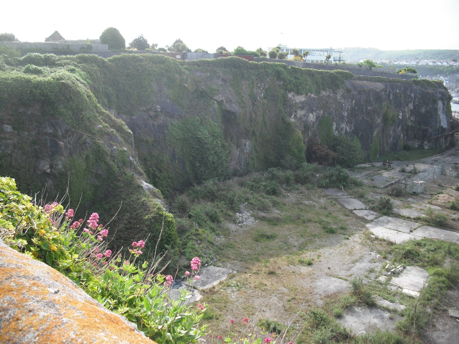
The last coastal stop before the walk into St Austell is Charlestown, a picturesque place used as a filming location for the TV series, The Onedin line. The port was built in 1791 – boats loaded clay on one side of the harbour whilst on the other they unloaded coal. It was said that you could tell which side of the port men worked by the colour of their faces! John Smeaton designed the harbour which was carved from solid rock.

Continue the walk into St Austell – or catch a bus from near Charlestown.

Photos show: view from walk between Fowey and Gribbin Head; Polkerris Beach; Charlestown. 


Thursday, 3 September 2015

Walk 140 Polperro to Fowey (Cornwall)

Walk 140 Polperro to Fowey (Cornwall)

(Second leg of English coastal walk – Broadstairs to Lands End)

Map: L/R 201 and 204
Distance: 10 miles or 15 km approx
Difficulty: moderate, demanding in parts
Terrain: coastal and cliff path
Access: Parking at both ends
Public transport: It is possible to get buses between the two towns but it involves changing and it is time consuming. Suggest Traveline website to fit in with where you are staying.

Take the path out of Polperro to the coastal path some parts of which are demanding. I found lots of dog walkers to start with. If they are under control fine and if on a lead where any other animals are likely to be around also fine. However, I had an altercation with the owner of a yappy dog who decided I was a miserable old b.....d for not letting his loose dog jump up and attack my lunch. His wife restrained him.

The walk continues with great views of Lantivet Bay and Pencarrow Head. Sharp craggy rocks, sandy coves and crystal blue sea dominate.

The first major settlement is Polruan. The National Coastwatch Institution on the outskirts is supported by voluntary contributions. Also look out for St Saviour's Chapel ruins – it was built in the 9th century and is preserved by English Heritage. The harbour at Polruan is a haven for small boats – it has a history of being a small fishing village and is situated on the edge of the River Fowey estuary. (NB to save embarrassment with the locals Fowey is pronounced 'Foy'.) Blockhouse forts were built across the river in the 14th century and a chain was strung across to prevent enemy ships from entering and was lowered for friendly ones. More recently the author Daphne Du Maurier was a resident of Polruan and a Daphne Du Maurier festival is held every year in nearby Fowey.

Follow the narrow hilly streets down to catch the ferry that regularly goes across to Fowey.

Fowey was once a staging post on the Saint's Way, the pilgrim route through Cornwall linking Ireland with Compostela in Spain. Yet another 'suspect' legend (see Looe Island) says that Jospeh of Aramathea visited here with the child Jesus. Apparently Joseph was a tin merchant with interests in the town. Fowey is one of Cornwall's oldest and most important ports. It was strongly associated with the china clay trade but today it is more recognised as a yachting centre.

Top photo: A view across Polruan to Fowey. Lower: St Saviour's Chapel


Wednesday, 26 August 2015

Walk 139 Seaton to Polperro (Cornwall)

Walk 139 Seaton to Polperro (Cornwall)

(Second leg of English coastal walk – Broadstairs to Lands End)

Map: L/R 201
Distance: 12 miles or 18 km approx
Difficulty: moderate
Terrain: coastal and cliff path
Access: Parking at both ends
Public transport: Direct buses go from Plymouth to Polperro every hour on weekdays and every other hour to Seaton. It is possible to get from Seaton to Polperro by bus but it is time consuming and involves a change.

Start the walk on the coastal path at Seaton. During the first mile you pass nearby a monkey sanctuary which cares for monkeys rescued from lives of neglect etc. Well worth a visit especially if you have interested children.

About a mile further on is Millendreath Beach, the crystal clear water here is typical of beaches along this coast. Continue walking to Looe.

The East and West Looe rivers join before entering Looe. This is an attractive place with its narrow streets and houses peering over the steep valley. However, the writer Daphne Du Maurier found the town claustrophobic because she felt the buildings were too close together. Archaeological evidence shows that Looe has been inhabited since at least 1000 BC. Further back in the town the bridge and boats provide an attractive vista. The bridge was built in 1853 but there has been one here since 1411. Looe was once a major port in Cornwall exporting tin, arsenic and granite. It was also a ship building town and fishing is still active with catches sold on the quayside. Looe is also a centre for shark fishing. Its development as a seaside resort started in Victorian times. It is considered one of the top UK places to celebrate the New Year with participants wearing all sorts of fancy dress.

Walk over the bridge and seawards on the west bank. Look out for the sculpture of Nelson a distinctive one-eyed grey seal who was a familiar site in the waters of south Cornwall for 25 years. He made the harbour his dining room and was popular with townspeople and visitors. A good reminder to cherish the marine life of the area.

Follow the road out of Looe on to Hannafore Point. This provides a good view across Portnadler Bay to Looe or St Georges Island. There is a legend that Joseph of Aaramathea landed there with the child Christ. It had a Benedictine chapel in 1139 and was later inhabited by the notorious smugglers Black Joan and her brother Fyn – they were said to have lived off rabbits and nuts. (Contraband can't have been much good then!) During World War 2 it was bombed by Germans who mistook it for a warship. In the 1960s it was bought by two ladies, ex teachers, who I had the pleasure of meeting before they died. They were self-sufficient until old age and made an income from visitors paying an embarkation fee to walk around the island and by selling refreshments in their cafĂ©. One of them also wrote a book 'We bought an island' which was on sale. An interesting read if you manage to get a copy. The island was left in the care of the Cornwall Wildlife Trust and can still be visited.
Continue walking around to Talland Bay and look out for the memorial cross providing a poignant silhouette against the sea.

The walk finishes at Polperro, another very attractive place. During the 17th and 18th centuries it was renowned for smuggling. John Wesley remarked when visiting the town in 1762: ' well nigh one and all bought or sold unaccustomed goods'. The whitewashed cottages scattered around the village were the original haunts of smugglers and fishermen. Cars are generally not allowed in the town but a 'tram' runs from the car park at Crumplehorn if you don't fancy the walk.   

Photos show: the beach at East Looe; boats near Looe Bridge; Polperro harbour.  


Thursday, 13 August 2015

Walk 138 Millbrook to Seaton (Cornwall)

Walk 138 Millbrook to Seaton (Cornwall)

(Second leg of English coastal walk – Broadstairs to Lands End)

Map: L/R 201
Distance: 13 miles or 20km approx
Difficulty: moderate
Terrain: coastal and cliff path
Access: Parking at both ends
Public transport: Buses run to and from Seaton and Millbrook to Plymouth – direct service every 2 hours

Parking may be available closer to the coastal path otherwise take the road out of Millbrook on to the coastal path to Tregonhawke. Walk from here to Freathy – the path follows alongside the road. Houses, bungalows and wooden buildings overlook the sandy beach.

Continue along to Tregantle Cliff where there is a choice depending on whether there is a red flag flying to show that the firing range is in use. The fort here was one of several built around Plymouth in the time of Lord Plamerston to deter the French from invading – 'Palmerston Forts'. In 1865 it had a barracks for 1000 men and 35 large guns. It is now a Royal Marine training centre.

After a mile or so descend into Portwrinkle which was formerly a pilchard fishing port. A few miles more cliff walking and you arrive at Downderry and its shingle beach. If it is clear enough, Eddystone Lighthouse can be seen 8 miles off shore. The original lighthouses were often mentioned in literature including Moby Dick.

The final stop is the attractive frontage at Seaton which is at the mouth of the River Seaton.   

Photos: Portwrinkle and Whitsand Bay; Seaton. 


Friday, 31 July 2015

Walk 137 Plymouth to Millbrook (Cornwall)

Walk 137 Plymouth to Millbrook (Cornwall)

(Second leg of English coastal walk – Broadstairs to Lands End)

Map: L/R 201
Distance: 13 miles or 20km approx
Difficulty: moderate
Terrain: coastal path
Access: Parking at both ends
Public transport: Buses run to and from the Cremyll Ferry, leaving from the Royal Parade in Plymouth. Bus 32 runs once and hour until mid-evening from Millbrook to the Royal Parade in Plymouth.

Get the Cremyll passenger ferry from near Stonehouse in Plymouth. On the way across there is a good view of the impressive naval buildings. The ferry has run for many years and was particularly busy with dockyard traffic in the 18th century.

On arrival at Cremyll is The Edgecumbe Arms, a pub with inviting outdoor seats giving excellent views across the water. Cremyll was an important place for boat building in the 18th century. The yard is still active building small boats and restoring historical craft. In World War 2 American soldiers were in this area preparing for the D Day landings.

The coastal path passes through Mount Edgcumbe Country Park although it is not always clearly marked by signs. The house and grounds here were to have been given to the Duke of Medina Sidonia from Spain if the Spanish Armada had been victorious in 1588. The house was built in the 1500s and was the former home of the Earls of Mount Edgcumbe. The house (in the summer) and 865 acre garden are open to the public.

Follow the path around Cawsand Bay and on to the twin attractive villages of Kingsand and Cawsand. The bay's most famous visitor was Napoleon whose ship anchored here after Waterloo. Evidently, hundreds of sightseers rowed out from the two villages to catch a glimpse of him. The local people also foiled an attempt to prevent Napoleon being exiled to St Helena. His friends had arranged for him to be presented with a writ requiring his attendance at London law courts. On hearing of this the locals towed Napoleons ship out to sea, leaving the lawyer behind.

Kingsand and Cawsand were originally split by the Devon/Cornwall border. Lord Nelson and Lady Hamilton were said to be regulars at The Ship Inn.

Continue the walk around Penlee Point and on to Rame Head. Walk up to the 14th century mariners chapel at the highest point of the head. The chapel is dedicated to St Michael and is thought to have been on the site of a Celtic hermitage. Take care coming down the steps. A lady walker slipped here when I was going up and the coastguard and ambulance took her away with a suspected broken collar bone. Waters off the headland are renowned for shark fishing. This is a good spot for bird-spotters with a great variety of species including the very rare Dartford Warbler.

The path passes Queener Point then goes alongside Whitsand Bay which has been notoriously dangerous for ships caught in south westerly winds as they tried to enter Plymouth.

At Tregonhawke follow the road into Millbrook. This village is at the head of a tidal creek which has been dammed to prevent floods. The resulting pool is a very pleasant place to sit and rest and is popular with bird watchers. The Flower Boat Festival takes place here on May Bank holiday each year. It dates back to the 14th century and is thought to be pagan in origin. The parade passes through Kingsand and Cawsand stopping at inns and houses on the way. A boat is carried decorated with flowers. In the evening it is put on the water with fireworks.

Photos show: naval buildings, Plymouth from the Cremyll ferry; Kingsand/Cawsand; Rame Head and chapel.


Tuesday, 28 July 2015

Walk 136 Plymouth (Devon) to Saltash (Cornwall)

Walk 136 Plymouth (Devon) to Saltash (Cornwall)

(Second leg of English coastal walk – Broadstairs to Lands End)

Map: L/R 201
Distance: 10 miles or 15 km approx
Difficulty: easy
Terrain: mainly roads
Access: Parking at both ends
Public transport: Trains between Saltash and Plymouth. Plenty of buses as well.

This walk involves some self-navigation on back streets and some walking along main roads which can be a bit tedious at times.

Start from Plymouth Aquarium. The walk from here can be via the footbridge at Sutton Harbour or along the road and past Lockyers Quay. Walk round the harbour and look out for the poles with fish sculptures at the top. These are near The Mayflowers Steps – many famous voyages left from here including The Pilgrim fathers to the USA in 1620 and in 1583 Sir Humphrey Gilbert sailed to claim Newfoundland for Queen Elizabeth 1st.

Alongside the quayside, near The Mayflower Steps, look out for two restored ships' cannons. These are from 19th century ships and are classified by the weight of the cannon balls they fired, in this case 24 pounders.

Just before getting to the Hoe is the Royal Citadel with its cannons poking over its 70 foot high walls. It was developed in the time of Charles 11 to counteract the threat of a Dutch invasion in the 1660s. It is still occupied by the military and if you are lucky you might be there on the day of a conducted tour.
Continue around to Plymouth Hoe and its iconic lighthouse. A park extends around the hoe and dates back to the medieval period when the first settlements occurred nearby – long before Francis Drake was supposed to have played bowls here waiting for the Spanish Armada in 1588. The Victorians created the park as it is today and they created a pleasant place to enjoy the panoramic view. If you have time you can go up Smeaton's Tower. He designed this lighthouse which was erected on the Eddystone Rock between 1756 and 1759. It was relocated to the Hoe in 1882 and on a clear day you can see its replacement out at sea.

The next stop is Western King Point near to Devils Point. Here there is a good view back to The Hoe. One of the grimmest parts of Plymouth's history is the trade from the 16th century involving Sir William Harvey. Manufactured goods were exchanged for African slaves who were then transported to the colonies.

Navigate around to The Great Western Docks where a waterfront walkway has been reclaimed. Look out for the plaques from past local machines, cranes and rail bridges on the roadside walls. In this area is The Royal William Yard with its impressive gateway and clock tower established by William 111 in 1691. Sorry for the imprecise directions but I wandered around the area to look for these landmarks.

Most of the walk from here to The Tamar Bridge is along the main road because there is no access to the naval dockyards and barracks. Just south of the Tamar Bridge is an area called Riverside. The memorial park here marks the point where members of the US Army left for the beaches of Normandy Hill on D Day in 1944.

Walk up on to the Tamar Bridge to cross to Saltash. This was opened in 1961 and when it opened it was the longest suspension bridge in the UK. It was the first bridge in the world to be widened using cantilevers - from 3 to 5 traffic lanes. About 40,000 vehicles use the bridge every day. Alongside the road bridge is Brunel's rail bridge which was opened in 1859 and considered to be one of his great achievements.

There are several things to look out for in Saltash. In the High Street is H. Elliott's old shop. It has been there since the start of the 20th century. The original owner's son, Frank, disagreed strongly with decimalisation and business rates in the early 1970s and stopped trading. He asked for the shop to be preserved in its original state and kept as a museum. It can still be visited but times of opening need to be checked.

A little way down the hill between Saltash and its waterside is Mary Newman's cottage. Francis Drake married her in 1569 – he was 24 and she was 17. They became Mayor and Mayoress of Plymouth after Drake was knighted in 1580. Sadly, she died from smallpox in 1583. The Grade 2 listed building is opened at certain times in the summer.

Continue down to Waterside. Look out for the artwork, especially the mural designed by a local artist which pictures significant events in Saltash. You will not miss the Union Pub with the huge Union Jack painted on its front. The street here used to be known as Pickle Cock Alley because of the shellfish that were sold from open windows. For 70 years from 1858 a ferry operated from the Waterside.

Before you leave Saltash look for the life sized sculpture of Isambard Kingdom Brunel. A photo opportunity!

Photos: Saltash Waterside -The Tamar Rail Bridge with the sculpture of Brunel in the foreground; H Elliott's preserved shop in Saltash; the gatehouse at Royal William Yard, Plymouth; some of the plaques on the wall at Great Western Dock. 


Wednesday, 22 July 2015

Walk 135 Wembury to Plymouth (Devon)

Walk 135 Wembury to Plymouth (Devon)

(Second leg of English coastal walk – Broadstairs to Lands End)

Map: L/R 201
Distance: 13 miles or 22 km approx
Difficulty: moderate
Terrain: coastal path and roads
Access: Parking at both ends
Public transport: Buses run from Wembury to Plymouth. This walk finishes at the aquarium – there are plenty of buses around the Plymouth city area.

Walk down to the coastal path from Wembury. Look out for The Marine Centre where you can learn about the local rock pools and what can be done to preserve them. Walk around Wembury Point to Heybrook Bay.

In 1956 Heybrook Bay was the site of the Royal Navy's chief gunnery school, HMS Cambridge, which had firing ranges near the village. It was closed in 2006 and the National Trust has worked hard to reinstate a natural landscape including demolishing the buildings. Much of the area along this coast is a European Special Area of Conservation because of the huge variety of marine plants, animals fish and birds.

Follow the path around to the picturesque Bovisand Bay. Opposite here, out in Plymouth Sound, is Plymouth Breakwater. This structure is 1560 metres long and 65 metres high and 4 million rocks were used in its construction in 1812. It was built to provide safe anchorage for the British fleet in the Napoleonic Wars. The lighthouse at the end was built in 1841. Near to the breakwater is a round fort built in 1865. It was armed with cannons but was disarmed well before World War 1. Since then it has been used as a signal station and a military training school.

The walk through Staddon Heights and towards Mount Batten provides good views of the Sound and the various vessels making their way in and out of Plymouth.

Nearer to Mount Batten there is a good view of Drake's Island. Originally this was called St Nicholas Island after the chapel there. It has only consistently been called Drake's Island in the last 100 years or so. Drake sailed from here in 1577 and in 1583 was made its governor. From 1549 it was fortified against the French and the Spanish with barracks on the island for 300 men. In 1963 Plymouth Council opened a youth training centre there.

After Jennycliff Bay there is a short climb to some seats at the top of Dunstone Point providing a panoramic view of Plymouth and the sea. After resting here continue to Mountbatten Headland where Mountbatten Tower is prominent.

This tower was thought to have been built between 1646 and 1652 probably in response to a threat of war from the Dutch. It was named after William Batten who had command of the Parliamentary Navy during the Civil War. It is built of local limestone with walls about a metre thick. Its last known use was as a coastguard observation post during the 19th century.

Near here was an RAF station for seaplanes in the Second World War based on an earlier base in the First World War. Look out for the memorial to RAF Mountbatten personnel killed between 1917 and 1992.

The route continues through the bustling Mountbatten Centre which is a major provider for outdoor adventurous activities. The stretch of water here is known as the Cattawater and is where the River Plym merges with Plymouth Sound. A water taxi can usually be seen going between this point and Mayflower Steps in the main part of Plymouth.

Further round is Turnchapel a rather unexpectedly quaint old fishing village. If you fancy a pint of real ale The Clovelly Inn may well be your stopping/resting point. Continue around the path and inlet to Turnchapel Hard. You may spot the memorial here dedicated to the embarkation of the US army to spearhead the Normandy Landings on D Day. The road was reinforced to carry the US tanks and personnel.

The path passes through Hooe Lake where a notice states that this is the hub of cross country paths and trails. Continue around to Laira Bridge where there are good views of the River Plym.

From here the path, called The Coxside Trail, winds its way round to Plymouth aquarium. A lot of this area was in the process of regeneration from a former industrial base when I walked it. In an area called Stonehouse there is a plaque which explains that in 1776 a cave was found which contained prehistoric bones. Further remains were found in the 19th and 20th centuries including humans, rhinoceros, lions and hyenas.

Continue on to The National Marine Aquarium which is the UK's largest and contains over 70 species of shark.

Photos show: a view of Heybrook Bay; a view from near Dunstone Point across to Plymouth; redevelopment alongside the Coxside Trail.