Total Pageviews

Monday, 26 September 2016

Walk 192 Bootle Station to Millom (Cumbria)

Walk 192 Bootle Station to Millom (Cumbria)

(Fourth leg of English coastal walk – Gretna Green to Chester)

Map: L/R 96
Distance: 16 miles or 26 km approx
Difficulty: Easy, flat
Terrain: coastal path, small amount of road. Some beach walking which could slow you down
Access: Parking at Millom, not sure about Bootle Station
Public transport: Trains between the two places. Millom has links to Barrow in Furness.

Follow the track from Bootle Station on to the Cumbria Coastal Way. The walk down to Silecroft is pleasant enough especially on a nice sunny day when I went. The coast is a site of special scientific interest for its bird and plant life – especially sedge warblers and orchids. However, don't expect to see much human life! 

After Silecroft, much of the walk is on the beach and care should be taken to stick near the dunes to avoid getting cut off – especially around Haverigg Point. The sandy area is called Haverigg Haws where there are breeding birds in the dunes. Look out for the sculpture on the beach side near Haverigg. It looks like a dragon and is called Escape to Light. It represents man flying from a dragon and giving in to temptations of greed and power and nature flying away from pollution and extermination.

Follow the coastal path that leaves Haverigg and goes round the outer man made barrier originally built in 1900 to protect iron ore mine workings. These subsided leaving large areas of water. The walk goes past the lighthouse, built in 1905, and refurbished in 2003. It now operates on a sensor and comes on as darkness falls – flashing every four seconds. Look out for the old lighthouse as you walk round.

Follow the path into the centre of Millom where a sculpture celebrates the towns heritage founded on the mines and iron works.

Photos show: part of the long, and for me, lonely stretch between Bootle Station and Silecroft; the old lighthouse from the outer barrier between Haverigg and Millom; the industrial heritage sculpture in Millom centre. 


Tuesday, 6 September 2016

Walk 191 Sellafield to Bootle Station (Cumbria)

Walk 191 Sellafield to Bootle Station (Cumbria)

(Fourth leg of English coastal walk – Gretna Green to Chester)

Map: L/R 89 and 96
Distance: 15 miles or 24 km
Difficulty: Easy, mostly flat
Terrain: coastal path, footpaths and roads.
Access: Not sure about parking at Sellafield
Public transport: Trains between the two places – either may be a request stop – can't remember (X on the destination board means you need to speak to the guard to stop the train).

Start the walk at Sellafield and walk south to Seascale alongside the railway line. Seascale was originally a Norse settlement and the name means hut or shelter by the sea. Evidence of an effort during Victorian times to make the town into a seaside resort is evident in some remaining fine Victorian houses. More recently its proximity to nearby Sellafield has sparked fears that childhood cancers are increasing. Research on this appears to be ongoing and seems to be suggest that this is not the case. The taxi driver mentioned in the walk through Whitehaven came from Seascale and killed two residents here when he ran amok. Look out for the Round Tower, this was a pumping tower dating from the days when Seascale had no proper water supply.

Take care if the red flag flying as this means that there is military activity on the shooting range further down the shore. So don't be tempted on to the dunes near Drigg but follow the path as marked on the map inland towards Drigg. Then navigate along minor roads to Saltcoats before crossing the bridge into Ravenglass.

Ravenglass is a pleasant spot and a good place to stop for refreshment. It may well be worth a day visit in itself. The Romans built a fort here and you can visit the remains of a bath house. The settlement is the only coastal village lying within The Lake District National Park. It is uniquely situated on the meeting of three rivers – The Esk, The Mite and The Irt. At the back of the town is The Ravenglass and Eskdale railway (I believe it is known as the Ratty) which was England's first narrow gauge railway. It was opened in 1876 to carry ore from local mines. It was closed in 1912 but was reopened much later as a successful tourist attraction. It goes 7 miles inland with trains pulled by steam and sometimes diesel. A great way to see some of the local scenery.

The walk down from Ravenglass is a bit of a slog mainly along the road. It was noisy with all the military shooting and explosions at Eskmeals. Not a walk I enjoyed and you could well skip it by getting the train from Ravenglass to Bootle.

Photos show: The beach with red flag near Seascale; the front at Ravenglass.


Sunday, 4 September 2016

Walk 190 Whitehaven to Sellafield (Cumbria)

Walk 190 Whitehaven to Sellafield (Cumbria)

(Fourth leg of English coastal walk – Gretna Green to Chester)

Map: L/R 89
Distance: 14 miles or 22km approx
Difficulty: Moderate – Bees Head is hilly, the rest is mainly flat
Terrain: coastal path
Access: Parking in each location
Public transport: Trains between the two places – this train has request stops and I can't remember if Sellafield is one of them

Before leaving Whitehaven you could take a walk to St Nichols Church where this a memorial to the children killed underground when working in the local coal mines. There is also a plaque to 'Farthing Jimmy' the nickname for Sir James Lowther (1673-1755) the richest commoner in England at the time who had a reputation for meanness (hence his nickname).

Walk out of Whitehaven towards the beacon. Down near the harbour is the Candlestick Chimney which ventilated Wellington Pit. Near here was Saltom Pit the first undersea coal mine sunk in 1731. On the hill is Duke Pit fan house a 19th century building which housed a fan for another coal mine. A few hundred yards along the path there is access inland to Haig Collery, a museum telling the story of coal mining in the area.

Follow the path along Bees Head with good views back to Whitehaven and, on a very good day, to the Isle of Man (about 30 miles away). The walk over Bees Head felt uncomfortably close to the edge at times. The cliffs rise to 100 metres and are the highest in north west England. The route got a bit confusing at times as there is quite a bit of quarrying of sandstone with safety fencing in place.

At North Head the lighthouse is a prominent landmark. It is here because of the great danger to ships with wrecks buried in the shingle beneath the head. It was the last lighthouse to use an open coal fire as a light source – it is now fired by an oil generator. I assume that the white tower at the side is a fog horn system. During World War 2 a radar station was based in the buildings next to the lighthouse. North Head marks the most westerly part of the Lake District. The cliff-top walk is the start of the coast to coast walk devised by Alfred Wainwright. (Finishes at Robin Hood Bay in Yorkshire).

Continue round the head and down near to St Bee's Beach, then into St Bees village. Look out for the sculpture of St Bega who lived here in the 7th century when she established a nunnery. The name of St Bees is a corruption of the saint's name; she was said to be an Irish princess who fled across the Irish Sea to avoid an enforced marriage. As you walk through St Bees look out for the Elizabethan School and the Norman Priory.

I could not find the path along the coast so had to walk along the road then farmland before joining the coast path, parallel to the rail line to Nethertown. The walk from here to Sellafield partly follows the coast but goes inland to High Sellafield across farmland. It did not appear to correspond to my map. Part of this walk is across a narrow hanging bridge which blows alarmingly in the wind – although the drop to the river is not that far. Again, the path to Sellafield itself has to be found along roads with the map not a lot of help – maybe later OS versions are clearer.

The nuclear power station here was called Calder Hall when it was opened in 1956. It was the world's first nuclear power station to generate electricity on a commercial scale. It was then called Windscale but after an accident in 1957 it was called Sellafield. When I was there it was undergoing decommissioning and dismantling. Don't wander around as there is strict security.

Photos show: Candlestick Chimney at Whitehaven; quarrying at St Bees Head; St Bees Head and beach; narrow suspension bridge near High Sellafield.


Sunday, 28 August 2016

Walk 189 Workington to Whitehaven (Cumbria)

Walk 189 Workington to Whitehaven (Cumbria)

(Fourth leg of English coastal walk – Gretna Green to Chester)

Map: L/R 89
Distance: 12 miles or 18km approx
Difficulty: Moderate – much is flat but there are hilly sections
Terrain: coastal path which includes some road walking
Access: Parking in each location
Public transport: Frequent service between the two towns 300, 130, 302 and 31. Trains are also possible.

To get to the path you need to start on the north side of the River Derwent. It can be a bit confusing depending on which part of Workington you start from. Follow the path out to the point, then it cuts southwards through the old steelworks. Tata still had a factory here when I went but I am not sure whether that is still the case. One things for sure, it is one of the most uninspiring coastal walks I have come across. Much of the area has been denuded of industry leaving swathes of rough ground. In its heyday the steelworks produced vast quantities of iron and steel assisted by a new process invented by Henry Bessemer. For mile or so the path passes alongside the railway.

The barren scenery fades when near to Harrington. Industry left here in the 1930s and there was once five rail stations (just one now). The harbour area was used in World War 2 for a secret magnesium works (extracted from sea water) to make aircraft parts. Look out for strange conical rocks which I assume are sea defences.

After Harrington the path cuts inland past a wind farm, then there is a bit of road walking into Lowca. In 1915 it was attacked by a German U-boat that surfaced close inshore and fired ineffectively at a chemical works; the first time a submarine had ever targeted a dry land location.

After walking through Parton there are good views back along to its harbour and the coast beyond. The path continues alongside the railway once again. Look out for two chimney like structures which connect to mine shafts that run a long way under the sea.

The walk finishes at the pleasant town of Whitehaven with its busy harbour. The town centre was inspired by Sir Christopher Wren's plans for rebuilding London after the Great Fire. Broad streets run down to the harbour. In the 18th century Whitehaven rivalled Liverpool and Bristol as a port and was the third largest town in the north of England. If you have time, go to the Beacon Museum with its interactive displays about the town's history. Whitehaven was attacked in 1778 during the American War of Independence. The famous John Paul Jones anchored his boat at nearby St Bee's Head but his plans went awry when the alarm was raised. A local told me it was because his men were drunk. Also worth visiting is The Rum Story which tells the story of its making and its association with the slave trade, the British Navy and smuggling.

A memorial garden in the town marks the tragedy on the day in 2010 when a taxi driver shot (mostly randomly) at several people.

Photos show: the site of old industry south of Workington; Harrington; mine shafts north of Whitehaven; Whiatehaven Harbour.


Tuesday, 23 August 2016

Walk 188 Maryport to Workington (Cumbria)

Walk 188 Maryport to Workington (Cumbria)

(Fourth leg of English coastal walk – Gretna Green to Chester) 2

Map: L/R 89
Distance: 9 miles or 14 km approx
Difficulty: fairly easy for the most part
Terrain: coastal path, some road
Access: Parking in each location
Public transport: 31 and 30 buses go frequently between the two towns

It is worth walking out on the harbour arm at Maryport to get good views before following the path around the marina. The town was built by the Senhouse family in the 18th century and Humphrey Senhouse named it after his wife Mary. It became an industrial port with the development of coal mining and the export of coal to Ireland and around the coast. The old Maryport to Carlisle Railway (1870-1927) enabled coal and iron products to be moved efficiently in and out of the port.

If you have time, the Maritime Museum at Maryport is good to learn more about the town. There is reference to Fletcher Christian here (mutiny of/on the Bounty) who he lived nearby. Many other interesting facts about the town can be discovered including the story of Thomas Ismay, founder of the White Star Line which built the Titanic.

In front of the museum is an interesting sculpture of fishermen by local craftsman Colin Telfer. He is the first artist to use iron ore in a sculpture, calling this one, 'A Fishy Tale'. The ore comes from Egremont near Whitehaven.

Look out for Elizabeth dock (which was named after Henry Senhouse's daughter) and the plaque marking the loss of three Maryport fishermen off Scotland in 2009. A major three day blues festival is held in the town and has attracted such artists as Jools Holland, Dionne Warwick and Chuck Berry.

Follow the path, which runs parallel with the beach, south out of Maryport. After a couple of miles you reach the old village of Flimby. The shoe firm New Balance has a factory here.

The walk between here and Workington is marked by a land wind farm and some industry. The path is clear enough but, when I went, it was a weekend and the area was dominated by youngsters speeding up and down on their motocross bikes. They are fast, throwing up clouds of dust and a bit scary as you hope you have been noticed.

On the way into Workington you need to cross the River Derwent. A policeman lost his life here directing traffic during the floods of 2009. The walk continues past the Workington Town Rugby League Club. The ground, which is shared with speedway, looked in poor shape to me. A more unusual sport, based in the town since the Middle Ages is 'Uppies and Downies'. It is a form of mob football which takes place between far apart places in the town (the harbour and some parkland). Injuries have been a concern!

Workington is a port and past industries have been based on coal, steel and vehicle manufacture. In the 2000s there was some regeneration which included the positioning of several works of art in the town centre.

Photos show: harbour at Maryport; the walk to Workington with wind farm and motocross.


Tuesday, 16 August 2016

Walk 187 Skinburness - Silloth - Maryport (Cumbria)

Walk 187 Skinburness – Silloth - Maryport (Cumbria)

(Fourth leg of English coastal walk – Gretna Green to Chester) 2

Map: L/R 85 and 89
Distance: 17 miles or 26 km.
Difficulty: fairly easy, mainly flat
Terrain: coastal path, some road
Access: Parking in each location
Public transport: 60 bus goes a few times day between the two locations. I got the 9:00 bus from Maryport which takes 30 mins to get to Skinburness. Whichever way, this is a longer walk than I normally attempt so allow a full day.

The comment at the end of this post is correct - navigating this section requires more map reading than usual as there are few markers to help.

I started by walking towards Grune Point. However, this is a very desolate spot with only the wide variety of bird life and the views of the aerials back at Anthorn to recommend it. In my view the extra couple of miles is not worth the effort.

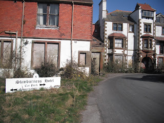
Start at the small settlement of Skinburness. The original town was engulfed in a flood in 1303, shortly after its harbour had been used as a base for Edward 1's attack on Scotland. When I went there the Skinburness Hotel was in a sad state of dilapidation. I was told that the area was shortly to be developed into a retirement village. Follow the coastal path down to the beach area. The Long House, now converted into two cottages, overlooks the beach. It is said to be the place where Bonnie Prince Charlie met the local Jacobites during the ill fated uprising in 1745.

Walk southwards, along the promenade, past the East Cote Lighthouse. This was originally established in 1864 as a mobile structure on a short rail track. It was fixed here in 1914 with a cabin below for the keeper. The light was automated in 1930.

Continue the walk down to Silloth and past some well tended, pleasant park land. The resort is little more than 100 years old. Sometimes known as Silloth on Solway it was developed in the 1860s when the terminus of a railway from Carlisle was built (it was closed during the infamous Beeching cuts of the 1960s). Before 1914 it was popular with the middle classes who came here for 'the air'. After this it became a destination for day trips for the working man and his family. Although it has declined, major events such as a music festival are attracting people again. It has a small port and large flour mill. Look out for millennium sculpture celebrating the main features of the town.

The walk southwards out of Silloth is a little tricky as it involves roads in the small dock area. Not very well marked when I went. Eventually, you arrive on wide expanses of sand. The walk follows the sand dunes although some can be done on the beach, and after a few miles, along the road. For several miles I saw very few people.

Soon after the path starts running parallel with the road you enter the small village of Beckfoot. A notice here states that you must not catch sea bass below the minimum size of 36cm. The sea here goes out a mile leaving pools known locally as 'scars'.

About 4 miles further down is Allonby. The village was a hotbed of whisky smuggling from Scotland in the 1700s.Look out for a large building set back from the road. This is North Lodge built in 1824 by a prominent Quaker called Thomas Richardson. He was a native of Allonby and a generous benefactor of the village who allowed many Quaker families to live rent free. The building is still owned by The Society of Friends. Be very careful as you walk through the village especially alongside the stream. There was a fatal accident involving a walker the day before I was there.

Oyster catchers, curlew, ringer plovers and the rare natterjack toad can be spotted in the dunes near Allonby. A couple of miles south is South Saltpan's Beach. It gets its name from an industry in Norman times when salt was extracted from sea water.

The only bit of hill climbing is on the outskirts of Maryport. Hadrians Wall, originally thought to have finished at Bowness on Solway, is now thought to have ended here at the site of the 1st century 'Avna' Roman Fort. The walk goes past the site and a museum is open to the public (but not when I was there).

As you enter Maryport the path allows good views of the town. The sunsets I saw were very attractive. More about the town on the next walk.

Photos show: The old Skinburness Hotel - what is it like now?; The millennium marker, Silloth; North Lodge, Allonby; South Saltpans Beach; sunset at Maryport.


Wednesday, 10 August 2016

Walk 186 Bowness on Solway to Anthorn (Cumbria)

Walk 186 Bowness on Solway to Anthorn (Cumbria)

(Fourth leg of English coastal walk – Gretna Green to Chester) 2
Map: L/R 85
Distance: 7 miles or 16 km approx
Difficulty: fairly easy, mainly flat
Terrain: Road following the cycle route
Access: Parking in each location
Public transport: 93 bus to Bowness on Solway from Carlisle currently leaves at 9:10. 93A bus currently leaves at 1:50 and 5:30 from Anthorn back to Carlisle.

This is a quiet walk – one of those where you are unlikely to meet many, if any, other walkers. However, you will see many cows ambling across and along the road. Leaving Bowness, there are several lay-bys on the road with view points to observe local bird life. The Campfield Nature Reserve is managed by the RSPB.

At Herdhill Scar there used to be a railway that went across the water on a 1940 yard viaduct to Annan in Scotland. It was opened in 1869 and had 192 arches. In 1875 it was damaged when water got into the hollow iron pillars; it froze and cracked them. Six years later ice jammed the estuary with ice up to 3 metres thick and ripped two gaps in the viaduct. This sort of damage was one of the reasons it was closed in 1924 and demolished in 1935. Another reason (apparently) was that Scots had no access to alcohol on Sunday and used to use the viaduct to cross to the other side. Occasionally, when they worse for wear, a few fell into the Solway and drowned.

After a few miles you come to the small settlement of Cardurnock with good views across the sand and mud flats. There is access to a flat beach here – definitely away from the crowds! Look out for what looks like a home made wooden seat at the side of the road.

The rather sinister looking aerials form the inland view for much of the walk to Anthorn. The aerials are up to 748 feet high and are VLF (very low frequency). They have been here since 1964 and are a link in NATO's defence system particularly transmitting to submarines. The area was once a landing strip for the military and this closed in 1958.

The housing development in the village of Anthorn once housed military personnel. The bus stop is here.

Photos: the aerials at Cardurnock; a view from near here across the Solway Firth.