Total Pageviews

Wednesday, 28 May 2014

Walk 117 Weymouth and Portland (Dorset)

Walk 117 Weymouth and Portland (Dorset)

(Second leg of English coastal walk – Broadstairs to Lands End)

Map: L/R 194
Distance: 17 miles or 25km
Difficulty: moderate
Terrain: road, cliff and other paths
Access: Parking in Weymouth.
Public transport: Plenty of buses between Weymouth and Portland.

This is a bit longer than the normal walks I do as it involves a circular walk around the island of Portland. Start off on the coastal path near to the George 111 statue in Weymouth and walk along the coastal path adjacent to the beach.

Look out for varied architecture including The New Vic Hotel which has a rather smart bust of Queen Victoria above its entrance. There are good views to the sheltered Weymouth Bay from here and soon the River Wey will have to be crossed for the walk to Nothe Fort. On the hills near Weymouth is a chalk carving of a horse meant to represent George 111 – dismayed that the work generated royal disapproval the artist killed himself. Fortunately, these days we are a little more sanguine about royal criticism – there would be an architect’s bloodbath if Prince Charles comments about some modern buildings were taken too much to heart!

The bridge across the Wey gives a good view up and down the river – lifeboats and old sailing vessels were in evidence when I was there. A plaque near here states that Captain Richard Clark departed from Weymouth to join Sir Humphrey Gilbert in his discovery of Newfoundland. Continue the walk up to and along the pier where ferries leave for the Channel Islands and Brittany. A less welcome visitor arrived here in 1348 as it was near Weymouth that the Black Death entered Britain killing nearly half the population in one year!

Weymouth Harbour was once a major port in the UK for both fishing and cargo – less so now although the catch is still the third largest in England. The bridge here is raised every two hours to let shipping through.

Continue the walk to Nothe Fort. This was built in 1860 by the Royal Engineers, with help from prisoners from Portland Prison, as part of the defence of Portland Harbour. It housed 12 gun batteries with 70 rooms on 3 levels. It remained in active service until 1956 and is now owned by the council.

Walk westwards and after about a mile is Sandsfoot or Weymouth  Castle and gardens. This was completed on the orders of Henry V111 in about 1539 to support Portland Castle in the protection of Portland Harbour. It has 2 storeys, dungeons, cannons and quarters for 50 men. The castle was in bad repair by 1584 due to damage by the sea and remedial work had to be done. It was held for the king in the Civil War and was then used as a mint. It then became a storehouse and never saw serious military action.

Portland Harbour was built in Victorian times and was an important naval base during the times of the Spanish Armada. It was closed (under the then name of HMS Osprey) in 1999 and the work transferred to Somerset. The cycle track along this stretch is part of The Rodwell Trail and follows part of the old Weymouth to Portland railway line which was closed in 1965. Look out for the platform and a sign of one of the old stations.

The walk along the road to Portland is a bit tedious. It becomes better near the end where there is a good view of Chesil Cave. This point, which lies at the end of Chesil Beach, gets the full blast of the Atlantic and is the site of many shipwrecks. The walk on the west side of the island starts with a rather steep and difficult climb alongside some houses to West Cliff. The path wasn’t entirely clear and it is possible that I took a route that was more difficult than it should have been. There is a very good view back to Chesil Beach which is one of the greatest examples of a tombolo in the world (a tombolo is a spit of land formed by longshore drift that has completely sealed in a section of the coast). The beach is 17 miles long and has been built up by a steady deposition of pebbles, the bulkiest near to Portland and the smaller down the coast at Abbotsbury. Local fishermen can tell exactly where on the beach a pebble comes from by its size.

Continue the walk along the path adjacent to the rugged coastline past Blacknor and towards Portland Bill. The scaly cricket’s only British home is in this area possibly brought here on a World War2 landing craft.

The 115 ft high lighthouse at Portland Bill was built in 1906 although there is an older disused one a little bit inland. To the right of it is an obelisk constructed in 1844 and warning of a low ledge stretching out 30 metres into the sea. Look out for Pulpit Rock further to the west which is a popular attraction because of its shape.

Continue the walk around the island where a mixture of erosion and quarrying has resulted in unusual rock formations. The area has been quarried for centuries to extract limestone. This has been used in such notable places as St Paul’s Cathedral, the Tower of London and the United Nations HQ in New York. Further round near Freshwater Bay there appears to be some new quarrying going on – a crane with a load still attached was abandoned – must have been knocking-off time!

Further up the east coast is Rufus Castle which is at the top of a steep climb from Church Ope Cove. The castle was built for William Rufus, king of England from 1087-1100, and is also known as Bow and Arrow Castle because of the many spaces for these weapons in the 7 ft thick walls. All that is left is a ruin and the arch is the only original part that remains.

Look out for the grim facades of the Young Offenders Institution and prison at Grove with the barbed wire and cameras. Near the end of the walk, on a hill near Fortuneswell, is an impressive sculpture of a quarryman. Descend into Fortunewell where there are buses back to Weymouth if needed.

Photos show: Chesil Beach from Portland; Portland Bill lighthouse; Quarrying areas on the south coast; sculpture of quarryman near Fortuneswell. 


Wednesday, 7 May 2014

Walk 116 Lulworth Cove to Weymouth (Dorset)


 Walk  116 Lulworth Cove to Weymouth  (Dorset)

(Second leg of English coastal walk – Broadstairs to Lands End)

Map: L/R 194
Distance: 13 miles or 20 km.
Difficulty: moderate/quite challenging in parts
Terrain: mainly cliff paths
Access: Parking at both ends.
Public transport: Train and bus are possible to Lulworth but involve a train and a bus - bare bones service. Taxi best option. Good bus and train links from Weymouth to surrounding areas.

This walk features some of the most outstanding views on the English coast. It is worth popping into the Heritage Centre at Lulworth Cove to learn about the area’s geology. Follow the coast path westwards and up the steps to Dungy Head. The view back makes clear the horseshoe shape of Lulworth Cove. Forward are the outlines of Weymouth and Portland with the dramatic cliffs of St Oswald’s Bay in the foreground.

Next up is the iconic ‘Durdle Door’, an arch of limestone rock. A unique species of butterfly, The Lulworth Skipper, was discovered here in 1832. The walk continues up to Swyre Head, the highest point of the Purbeck Hills which form this part of the coast. (The area between Durdle Door and here is known as Scratchy Bottom!)

A little further along is Bats Head. There is a small gap near the point of the head and it is thought that erosion will eventually lead it to looking much like Durdle Door.

Continue along to White Nothe then Ringstead Bay – an area popular with divers. Burning Cliff, which overlooks the bay, is owned by The National Trust and is so called because in 1827 a peat fire, possibly started by lightning, burnt for six years.

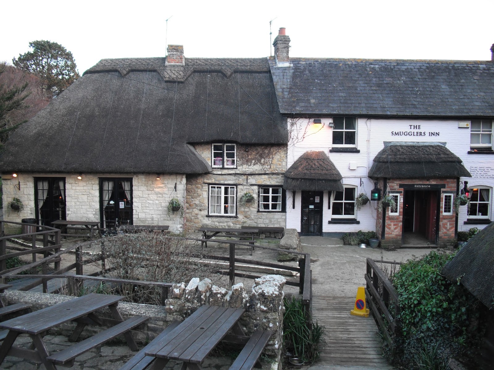
A mile or so further along is the settlement of Osmington Mills. The mills were water mills which were used to grind corn. The Smugglers Inn, once the house of notorious smuggler, Emanuel Charles, dates back to the 13th century. John Constable came here in 1816 on his honeymoon and the views inspired his paintings of the Weymouth coast.

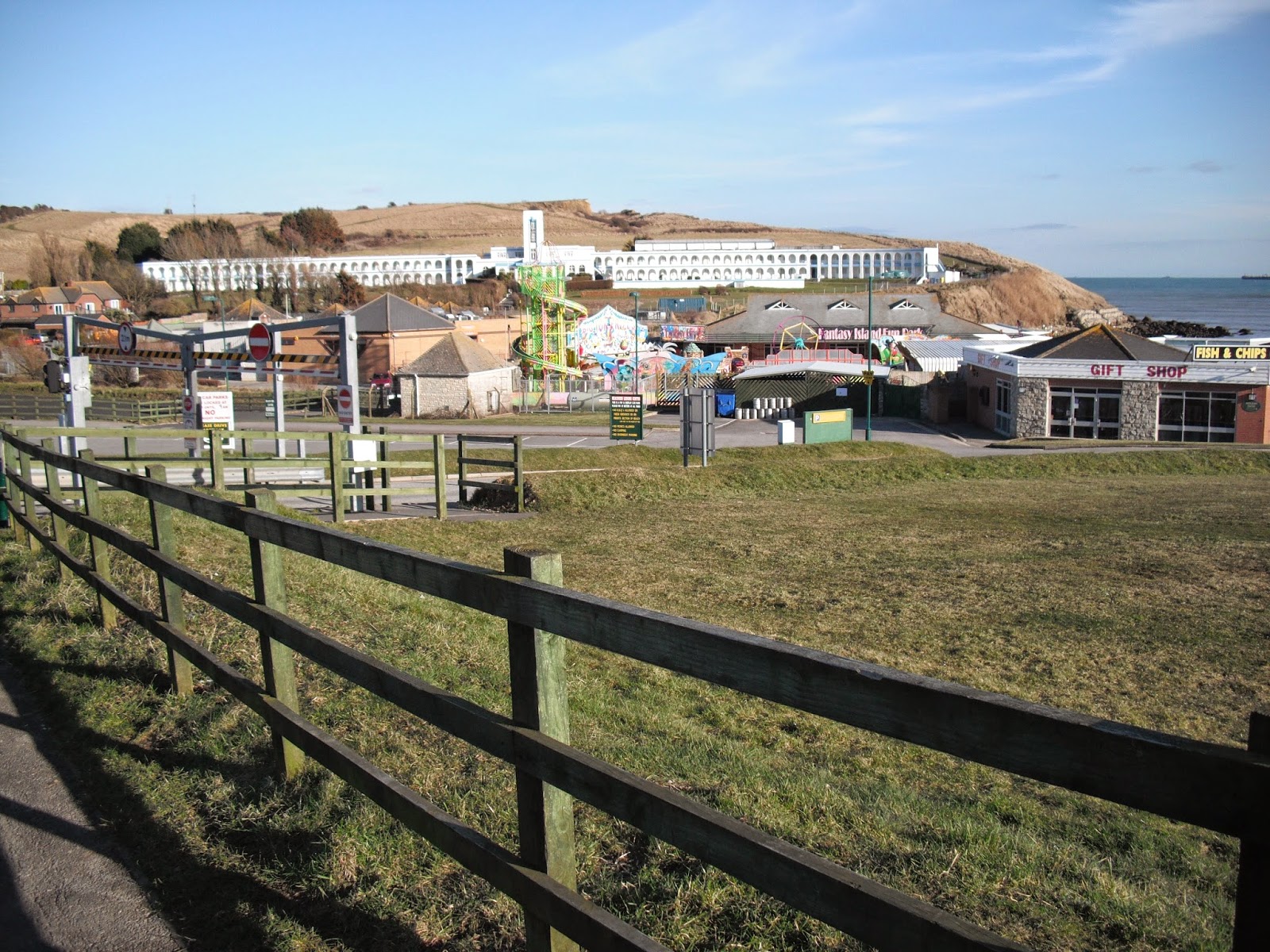
Continue along passing Black Head and an activity centre and on to Bowleaze Cove. This is a popular area for holiday makers with the Waterside Holiday Park an additional attraction. However, it is the long white building that sits above the village which is most impressive. This a grade 2 listed building designed in a Spanish Riviera style. It was owned by Pontins between 1950 and 1960 but was back as a hotel when I went there. The exotic sounding River Jordan exits on to the beach. Curiously, remains of elephants have been found in the area.

Continue along Furzy Cliff where there is a panoramic view of Weymouth and Portland. Descend on to the sea front where a piece of sculpted rock marks the recent building of sea defences. The entry promenade road into Weymouth has a row of colourful B&Bs/guest houses. Further along there is a mixture of Georgian and Victorian buildings. Look out for the pavilion jutting out on to the beach, this was built in 1960 to replace one destroyed by fire in 1954.

There are several things to look out for on the front. The ANZAC memorial (Australia and New Zealand) commemorates the troops from these countries who were stationed in Dorset and moved to fight in Palestine. The colourful clock tower commemorates the jubilee of Queen Victoria in 1887. The war memorial on the Esplanade features 3 events: 749 men killed off nearby Lyme Bay when they were attacked by torpedoes when training in 1944; also in this year 802 men died when their troopship sank in the channel; approx. 3000 American troops died after they left here for Omaha beach on D Day.

Further along is a full size replica of a bathing machine used by King George 111 during one of the 14 summers he spent here between 1789 and1805. On first arriving he was so impressed by the views that he exclaimed ‘I never enjoyed a sight so pleasing’. However, Queen Mary thought it a dull and stupid place!

Do not miss the impressive George 111 statue. Part of his cure, for what was then known as ‘the king’s madness’, (in fact a chemical imbalance in his body which damaged his nervous system) was to bathe in the sea water. The king’s visits helped to establish Weymouth as a popular resort and the statue was funded by ‘the grateful inhabitants’. The railway station is close to this area.

Photos show: Durdle Dor; Osmington Mills; Bowleaze Cove; View to Weymouth and Portland; George 111 statue in Weymouth. 


Wednesday, 23 April 2014

Walk 115 Kimmeridge Bay to Lulworth Cove (Dorset)

 Walk  115 Kimmeridge Bay to Lulworth Cove  (Dorset)

(Second leg of English coastal walk – Broadstairs to Lands End)

Map: L/R 195 and 194
Distance: 8 miles or 12 km.
Difficulty: challenging especially if muddy – some slippery slopes
Terrain: mainly cliff paths
Access: Parking at both ends. NOTE: This walk is on the Lulworth firing ranges and is only open at certain times. Check on: dorsetforyou.com before going.
Public transport: There appear to be no options for Kimmeridge. A morning bus service goes from Wareham to Lulworth. Local taxis specialise in the trip. I left my car at Lulworth Cove car par and arranged (in advance) for a taxi to Kimmeridge. A bit expensive but OK if you can share with other walkers.

Follow the coastal path westwards out of Kimmeridge Bay. Soon you will come to a ‘nodding donkey’ pumping up oil from a small BP well. This has been tapped for over 40 years and has been producing about 80 barrels a day. From Iron age times, oil shale (oil impregnated soft slate) was extracted and used to produce artefacts including jewellery and furniture. In the 1850s the oil was exported to Paris as fuel for gas lit lamps.

About a mile further on, past Howbarrow Bay, is Gad Cliff which overlooks Brandy Bay. This bay derives its name from the smuggling that took place in the 17th and 18th centuries. About a mile further along is Worbarrow Tout which sticks out impressively into the sea. Care is needed on the walk down from here and up the steep path to Flowers Barrow (no steps or handrail). I fell at this point and ended up at the doctors with a knee injury. I did manage to hobble on to Lulworth Cove though.

Inland from here is the ghost village of Tyneham. It can only be accessed when the coastal path is open. The village was seized by the army in 1943 on Churchill’s orders and used for practising manoeuvres. The occupants were moved out and tanks moved in (as did thieves who stripped the buildings!). The village is still empty despite years of protests.

Flowers Barrow, which overlooks Warbarrow Bay, was the site of an iron age fort and has been eroded over the years. There appears to be no evidence that it was much more than a small settlement.

Visible from the path near here is Lulworth Castle which is a mile or so inland. It was built in the early 17th century by Thomas Howard as a hunting lodge, it then became a country house. It was gutted by fire in 1929 and was restored in 1998.     

 As you approach Lulworth Cove the views back to the east are stunning. The first view of the cove is the large car park and road stretching up the hill. Descend into the cove which is famous for its geology and picturesque outlook. The entrance to the cove is narrow because the rocks at this point are formed of the hard Portland Stone whereas the softer Purbeck stone in the cove is still eroding.

|Photos show: nodding donkey at Kimmeridge Bay; Gad Cliff and Brandy Bay; Warbarrow Tout; Lulworth Cove.


Tuesday, 8 April 2014

Walk 114 Worth Matravers to Kimmeridge Bay (Dorset)

 Walk  114 Worth Matravers to Kimmeridge Bay  (Dorset)

(Second leg of English coastal walk – Broadstairs to Lands End)

Map: L/R 195
Distance: 8 miles or 12 km.
Difficulty: very challenging especially if muddy
Terrain: cliff paths
Access: Parking at both ends
Public transport: Very difficult. No 44 bus goes from Swanage to Worth at 12:11 and 14:11, the latest return journey appears to be 12:43. There appear to be no options for Kimmeridge. Taxi the only other option.

Follow the roads and tracks out of Worth Martravers and take the path westwards towards Houns-Tout Cliff. The steps up to the cliff top here must be one of the longest and steepest straight climbs on the coast anywhere in England. There is a good view back to St Aldhelm’s or St Alban’s Head. This stretch can get very muddy and needs great care if it is. I fell into the mire three times! Although a relatively short walk allow good time to complete it.

Continue walking to Egmont Point where there is a view of Swyre Head - an old Saxon Barrow. Kimmeridge Ledges provide interesting rock formations – the area is popular with geologists and surfers.

Clavell Tower is to the east of Kimmeridge Bay. This was built in 1831 by the Rev. John Clavell as  an observatory and folly. By 2005 erosion meant that the tower was very near the cliff edge so it was dismantled and rebuilt further back by The Landmark Trust. The writer Thomas Hardy courted one of his early loves, Eliza Bright, here and used the tower as a frontispiece for his Wessex Poems. The building also inspired the novelist P D James when writing her novel The Black Tower.

Continue round and down the steps where there is a good view of Kimmeridge Bay and beyond. The cliffs are famous for the fossils found in the alternate layers of limestone and clay. This is a very popular location with educational groups of all ages. In the past locals used to gather bituminous shale from the shore for extra fuel in winter. Reportedly, “Kimmeridge Coal” has an acrid and pungent smell when burnt.

Look out for the wild cabbage that grows here, it is the ancestor of modern cabbage, cauliflower and brussel sprouts. Unusually, due to its position, Kimmeridge Bay has two low tides each day.

Photos show: Looking eastwards near Chapman's Pool; Swyre Head; the path near Kimmeridge Ledges; Clavell Tower; Kimmeridge Bay.


Wednesday, 19 March 2014

Walk 113 Swanage to Worth Matravers (Dorset)

 Walk  113 Swanage to Worth Matravers (Dorset)

(Second leg of English coastal walk – Broadstairs to Lands End)

Map: L/R 195
Distance: 12 miles or 18km approx.
Difficulty: quite challenging
Terrain: cliff paths, some road
Access: Parking at both ends
Public transport: Difficult both ways. No 44 bus goes from Swanage to the village at 12:11 and 14:11, the latest return journey appears to be 12:43.Taxi to the village might be the best option.

Start the walk from the pier and go westwards out of Swanage. You will pass a couple of pillars of Purbeck stone on the land side of the road. The Dorset coast and countryside are the setting of Thomas Hardy’s novels. He stayed in Swanage in 1875 and the town is referred to as Knollsea in his novel, The Hand of Ethelberta.

Continue the walk to Pevril Point. From here there is a view back to Old Harry Rocks and another forward to Durlston Head. Near the coastguard building are underground tunnels which connect to disused gun emplacements. Peveril point is made from limestone does not erode easily compared to Dalston Bay which is clay and does.

The walk passes around Durlston Bay, and goes through the country park The whole of the area is known as The Isle of Purbeck and it was joined to the Isle of Wight about 50000 years ago.

The next main feature is the globe at Durlston Head, a nearby plaque shows that the head is 1491 feet above sea level. The Great Globe is made from 40 tons of Portland Stone. From this point, the first Dolphin Watch was set up in 1967 – bottle nosed dolphins are the most frequently seen species. Much of the Dorset coast is known as the Jurassic Coast and it was England’s first World Heritage Site.

Just before the Tilly Whim Caves is Freestone an old tourist attraction which is no longer open to the public because of a rock fall. It was used extensively in the Napoleonic Wars for fortifications, however, after 1815 there was little activity apart from smuggling. It was closed in 1976.

A bit further round are the Tilly Whim Caves. These were originally limestone quarries mainly worked during the 18th century. The name comes from a quarryman named Tilly and type of crane used then called a Whim. Skilled stonemasons worked much of the stone on site e.g. into sinks and troughs.

A short walk from the caves is Anvil Point. The lighthouse here is open to the public for most of the year. It was built in 1881 and was opened by Neville Chamberlain’s (the former prime minister) father who was Minister of Transport. It provides a way-marker for ships passing along the English Channel.

In about a couple of miles look out for the rocks of Dancing Ledge. It was called this because it was the same size as a ballroom floor and is a remnant of the Purbeck quarrying industry; it was last used in the 1930s. Stone from here was shipped to Ramsgate in Kent to build the harbour there. A swimming pool was once blasted into the rocks at Dancing Ledge for use by local preparatory schools. The cave at the eastern end houses some Great Horseshoe bats – an endangered species.

The walk continues along Seacombe Cliffs where there is further evidence of quarrying. Further along is Winspit which provides an interesting landscape of quarrying remains and World War 2 gun emplacements. The quarry closed in 1950 but it was used for a 1979 episode of Doctor Who.

The next main feature is St Adhelm’s or St Alban’s Head. Look out for the metal sculpture on the cliff top. This commemorates the radar research carried out at nearby Worth Martravers between 1940-42 – crucial to the war and modern telecommunications. The chapel on the Head is thought to date back to 1150 and is dedicated to the first Saxon bishop of Sherborne (in west Dorset). The square building has corners which point to the 4 main points of the compass. It is thought to have been a chantry where mass was said for sailors and it was also a beacon for shipping.

Continue the walk across Emmetts Hill, with views to Chapman’s Pool. Descend the steep steps and navigate into Worth Martravers. This is a picturesque village that dates from the 14th century and was the home of the wealthy Martravers family. Most of the current buildings date from the 18th and 19th centuries. In 2004, local fishermen had their work sabotaged by The Lobster Liberation Group. The local pub, The Square and Compasses, has an annual stone carving competition marking the importance of quarrying to the area.    

Photos show: Worth Martravers; St Aldhelm's Chapel; Dancing Ledge; Tilly Whim Caves; The Great Globe; Winspit.


Friday, 28 February 2014

Walk 112 Brownsea Island then Sandbanks to Swanage

Walk  112 Brownsea Island then Sandbanks to Swanage (Dorset)

(Second leg of English coastal walk – Broadstairs to Lands End)

Map: L/R 195
Distance: 13 miles or 21 km approx
Difficulty: moderate
Terrain: paths/ pavement/sand
Access: Parking at both ends
Public transport: Regular bus links from Poole to Swanage and Sandbanks. Ferry to Brownsea Island runs late March to early November – check times before travelling.

Brownsea Island is owned by the National Trust and it is worth signing up for one of their conducted tours (if available) to find out much of interest. These walks don’t cover the whole island but here are paths which can be walked independently.

There have been settlements on Brownsea since the 5th century BC and these include Viking settlers and an abbey. Henry V111 first built a castle on the island and there were several owners who have added to it or rebuilt it. These include ‘Mad’ Benson in the 1700s who was said to dabble in black magic, a Colonel and his wife in the 1800s who became bankrupt after building a large pottery and chapel, Major Balfour who rebuilt it after a fire, the Van Raalte family who filled it with musical instruments and Mary Bonham Christie a reclusive eccentric who let the island drift back into a natural state. When she died in 1961 the island was taken over by the National Trust. The major retailing company John Lewis has contributed to the repair of the island including the castle which is now used by their employees as a hotel.  There are red squirrels, deer and a wide variety of birds to spot.

On return to Sandbanks get the chain ferry over to South Haven Point on the opposite bank. The ferry has been running since 1923 and saves a 25 mile road journey. On the other side there is a short walk to Studland Bay and the start of the South West Coastal Path – announced in a metal sculpted sign. The path is over 600 miles long and ends in Minehead in Somerset.

The walk across Shell and Studland bays is probably best undertaken on the firmer sand nearer to the sea. The area is home to three of Britain’s native snakes: the adder, the grass snake and the rarer smooth snake. The latter creature feeds on the equally rare sand lizard which also lives here. Studland means ‘land where horses were kept’- presumably some of these would have belonged to pirates and smugglers who were active here in the 18th and 19th centuries. Parts of the beach are frequented by naturists – I took some children across the sands several years ago without realising this  – judging by the sniggers my pathetic attempts to persuade them to avert their eyes were largely ignored.

After a couple of miles or so the path leaves the beach and goes along the cliff top. Near Redend Point is Fort Henry – the largest and strongest World War 2 observation post to be built in Britain. It was constructed by Canadian engineers in 1943. Studland Beach had a high profile throughout the war, even the sea was set alight with petrol as part of a deterrent and around 5000 mines were positioned on the sands.

Continue the cliff walk to The Foreland or Handfast Point. The area is known as the Isle of Purbeck but it has long ceased to be an island. Next to the sheer chalk white cliffs is Old Harry a stack that marks the point where the Purbeck Hills fall into the sea below Ballard Down. Old Harry is about 200 years old and it used to be accompanied by a smaller stump called Old Harry’s Wife but this collapsed in the 1950s. If you are lucky you can still see this during low spring tides. The name Old Harry refers to the devil who is said to have rested on the rock, although others suggest it was named after a famous pirate.

Continue around Ballard Point enjoying the spectacular white cliffs beneath your feet. As far back as the middle ages this area was quarried for lime stone and Purbeck marble was used in Salisbury Cathedral and Westminster Abbey. Soon Swanage comes into view where the stone has been used to help improve the appearance of the town.

Before tourists became the main source of the town’s income Swanage was the centre for shipping Purbeck stone to London. When the empty sailing ketches started sinking on their return from London they were loaded with unwanted heavy street items from the Victorian streets of the capital. Swanage then earned the name Little London as many of these ballast items were incorporated into the streets of the town. Look out for them!

Carry on the walk to the pier. The original pier was built in 1860 and used mainly for shipping stone. It is now used for leisure and volunteers have helped to repair recent storm damage. Walk inland from the pier to the Swanage Railway terminus. Trains first ran on the branch line to Swanage in 1882 but it all came to an end in 1972 when British Rail closed it. Fortunately, The Swanage Railway, a charity, took it over and it has been rebuilt by volunteers. Steam and diesel trains operate daily during the summer and at certain other times. This is a great way to go to inland Corfe Castle (on another day) and explore the ruins where Edward the Martyr was murdered in 978.

Snaps show: Studland Bay; the start of the South West Coastal path;Old Harry rocks; Swanage Beach; the twin Purbeck pillars on the walk out of Swanage; the Swanage Railway.


Thursday, 6 February 2014

Walk 111 Bournemouth to Poole (Dorset)


 Walk  111 Bournemouth to Poole (Dorset)

 (Second leg of English coastal walk – Broadstairs to Lands End)

 Map: L/R 195
Distance: 13 miles or 20km approx.
Difficulty: quite easy
Terrain: paths/ pavement
Access: Parking at both ends
Public transport: Rail and bus links Bournemouth/Poole

Start the walk at Bournemouth Pier. Follow the cycle route along the coast as marked on the OS map.

The first main feature is Alum Chine. It gets its name from an unsuccessful attempt to mine alum (a fixative used in the dye industry) and copperas (a black die used in ink). It proved uneconomical and mining ceased by the end of the 17th century. If you enjoy gardens, look out for the Alum Chine Tropical Gardens which can be viewed from a special platform.

There are a few chines (wooded valleys) along this stretch including Flag Head Chine and Canford Cliffs Chine. The valley at Branksome Chine cuts inland for about 1.5 miles.

Continue walking to Poole Head then follow the cycle track over the B3369 where it continues towards Sandbanks. Take a stroll along here where the view is to Brownsea Island and Poole. Much of the coast around Sandbanks is inaccessible because the gardens of some very expensive housing run down to the beach. This area has one of the highest (probably the highest) property values in the UK. I understand several celebrities and Premiership footballers live here.

After the stroll turn around and follow the road (a bit of a route march in parts) around to Poole then walk around Parkstone Bay following the cycle route. The entrance to Poole Harbour is soon reached.

Poole has been a port since the 12th century prospering during the height of the wool trade to become one of the busiest ports in the UK in the 18th century. It also prospered as a base for privateers (had a licence from the government to act moreless like pirates) and in 1405 was sacked (attacked and plundered) in vengeance by the French and Spanish.  During World War 2 it was one of the main departure points for the D Day landings. Sixty cutters of the US Coastguard Rescue service were stationed here – they were completely made of wool.

The harbour, the largest natural one in Europe, is full of extremely expensive looking boats – some under construction. There is a double high tide which means it remains high for more than half the day.

On the harbour side, look out for the seated figure of Baden Powell. This is a memorial to the man who organised the first scout camp at nearby Brownsea Island. (Details on next walk). A sculpture called ‘Sea Music’ by the artist Sir Anthony Caro is also at the edge of the harbour. The HQ of the RNLI together with the lifeboat college can be found further round on the walk to Holes Bay with its odd sculptures on the harbour side. At Holes Bay return to Poole centre and bus/train/car.

Snaps show: coast near Branksome Chine;  'Sea Music' sculpture, Poole; a view to Sandbanks; Poole Harbour.