Total Pageviews

Monday, 8 April 2013

Walk 93 East Wittering to Bosham


 Walk  93   East Wittering to Bosham (West Sussex)

(Second leg of English coastal walk – Broadstairs to Lands End)

Map: L/R 197
Distance: 11 miles or 16km approx.
Difficulty: Fairly easy – stony beach walking can be tiring
Terrain: Paths, pavements, beach  
Access: Parking at both ends
Public transport: 52/53 frequent service from Chichester to East Wittering Mon – Sat (once and hour on Sunday). 55A Bosham to Chichester every hour or so Mon-Sat (a few on Sundays).

This walk can only be done between mid May until the end of September as it involves using the West Itchenor ferry.

The first part of the walk from East Wittering/Bracklesham Bay is along the pebbly beach. A very large caravan park is on the eastern side with some interesting modern houses overlooking the beach. Portsmouth and the Isle of Wight are usually visible from here. The beach was used by Canadian forces to practise for D Day in 1944. Now it is very popular with surfers.

Continue the walk on the path alongside the sandy shoreline to the entrance to Chichester Harbour. Some of the houses along this stretch have their own beach gardens. There is a choice at the end of this path either take a walk around East Beach or turn right and continue past West Wittering. The sandy dunes along here make it a pleasant spot to sit and rest. Much of the area is managed by The National Trust and it has a range of wildlife specific to the conditions.

The walk continues past West Wittering through an area called Snowhill (no snow, no hill). Carry on to West Itchenor, a village which appears to be dominated by the sailing community. Catch the seasonal ferry from here to Smugglers Lane on the other side. As the name suggests there was a lot of smuggling in the area especially the sending of brandy into Chichester. The ferry dates back to the 17th century and, following a period when it was out of use it was reinstated in 1976.

Follow the path into Bosham which is a very attractive place. When the tide is in it covers the road and you can see how houses have been specially adapted to cope with this. If the tide is out there is an extraordinary, picturesque stretch of green algae instead of the water.

The village goes back to Saxon times. Legend tells of a Danish raid in which the church bells were stolen. The Danish ship sank in the channel and the lost bells are said to ring in answer to the present bells. It was at Bosham that King Canute supposedly tried to turn back the waves (other places make this claim as well) – legend also has it that his young daughter was drowned in a millstream nearby and was buried in the church. In 1865 an excavation found the bones of a girl about 8 years old so maybe it is true. Bosham Church is depicted in the Bayeux Tapestry showing King Harold going in there to pray for safe passage to Normandy in 1064.

Snaps show: East Head, Chichester Harbour; buildings on the beach Brackleshem Bay; Snow Hill; Bosham.


Monday, 18 March 2013

Walk 92 Pagham to Selsey


Walk   92   Pagham to Selsey (West Sussex)

(Second leg of English coastal walk – Broadstairs to Lands End)

Map: L/R 197
Distance: 10 miles or 16 km approx.
Difficulty: Easy
Terrain: Paths and pavement
Access: Parking at both ends
Public transport: 51 bus from Selsey to Chichester, 60/700 Pagham to Chichester

Start at Pagham and take the path that skirts around the edge of Pagham Harbour to Church Norton. This is a pleasant, peaceful walk with good views.

Pagham Harbour is 1000 acres of natural saltmarsh, lagoon and tidal mudflat. It is now a significant nature reserve with 200 species of birds, 340 varieties of flowering plants and even 13 species of woodlice. There was a harbour here from 1345 until 1875 but it became silted up and much land was reclaimed. However, in 1910 a combination of high tide and heavy rain punctured the sea wall and the water spilled back in.

To the south of Sidlesham there is walk along the main road before returning to the path. Look out for the old thatched cottage and the many geese.

At Church Norton is St Wilfred’s Chapel, it is still used and was open to visitors when I went. The main church which gave the settlement part of its name was moved to Selsey in 1865. A large graveyard provides evidence of a much larger population in the past.

On the approach to Selsey some conversions of old railway carriages are easy to spot. Look out for the plaque to Eric Coates who was inspired by the view back to Bognor Regis and composed The Sleepy Lagoon in 1930; this became the signature tune for the BBC radio programme Desert Island Discs.

The walk continues along the promenade to Selsey Bill, this low lying headland is the most southern point of Sussex and has eroded more in the last century than any other part of the UK. The famous Mulberry Harbours were assembled off Selsey. Sections of concrete were assembled, towed to the Normandy Beaches and used in the D Day landings of 1944.

Walk past the lifeboat station and pier to the beach at West Selsey. Here there are some strange looking conical stone structures on the beach – I have not been able to find out what these were/are for.

Selsey was the centre for a thriving mousetrap industry in Victorian times. They were taken by cart to Chichester and exported to countries around the globe – evidently they never wore out! A famous resident in the distant past was St Wilfred the patron saint of Sussex and one time Bishop of Northumbria. He was shipwrecked here in the 7th century and returned a few years later to found a monastery, which, because of the sea encroaching, was later moved to Winchester. A more recent resident of Selsey was the astronomer Patrick Moore.
Snaps show: two views of Pagham Harbour; St Wilfred's Chapel; Selsey Bill.


Thursday, 7 March 2013

Walk 91 Littlehampton to Pagham


Walk   91   Littlehampton to Pagham (West Sussex)

(Second leg of English coastal walk – Broadstairs to Lands End)

Map: L/R 197
Distance: 11 miles or 18 km approx.
Difficulty: Easy
Terrain: Paths and pavement some beach walking if preferred
Access: Parking at both ends
Public transport: regular buses from Littlehampton (700) change at Bognor Regis for 60 to Pagham.

Take the walk out of Littlehampton along the west bank of the River Arun then follow the path which runs along the edge of the golf course to Climping Beach and the small settlement of Atherington. From here to Bognor Regis access to some of the beaches is restricted as they are privately owned. If you walk below the high tide mark then (so I have been told) it is OK as this part is not owned by anyone. However, I tend not to do this having been bitten by a dog which was released by its arrogant owner in a similar situation.

Further along is Middleton on Sea. The village grew from a World War 1 sea base to become a holiday destination. Follow the road, promenade or beach along to Felpham with its brightly coloured beach huts and larger wooden structures (presumably used for holiday accommodation). William Blake the artist and poet lived here for three years (1800-1803) and the house is still there.

The walk progresses seamlessly into Bognor Regis, the first noticeable buildings are the tent like structures of the Butlins complex.

In the late 1780s, Richard Hotham, a well known London hat-maker, decided to create a new watering place to rival Bath and Brighton. He wanted to call it Hothamton but he died before this could happen and it retained the name of Bognor (which comes from the Saxon for ‘rocky shore’). Following a visit from King George V the resort gained its royal suffix ‘regis’. On his death bed he is said to have uttered “bugger Bognor” when told by his physician that he would be going back there to convalesce after his illness. Most buildings along the seafront are forgettable. Two exceptions are the impressive Royal Suffolk Hotel and The Royal Hotel.

Bognor pier has had a similar history to many others in the UK. It was built in 1865 and was 1000 feet long. From 1909 it had a large theatre, cinema, restaurant and 12 shops. In 1964/65 the sea end of the structure collapsed in a storm and in 1974 two fires broke out. In 1999 more serious storm damage occurred and the rather short structure is the one that can be seen today.

The walk continues out of Bognor Regis and on to Pagham. To appreciate the views, follow the path and then turn north along the narrow strip of land between the lagoon and Pagham Harbour. Many of the original beach dwellings are bungalows originally constructed from old railway carriages. A friend of mine used to stay in one of the carriages before they were converted when on his family holiday in the fifties/sixties.

The walk finishes at Pagham – mainly bungalow land although it dates back to the 13th century.
Snaps show: the two hotels on Bognor seafront; a view to the beaches near Middleton on Sea; Butlins at Bognor.

Monday, 18 February 2013

Walk 90 Worthing to Littlehampton


Walk   90   Worthing to Littlehampton (West Sussex)

(Second leg of English coastal walk – Broadstairs to Lands End)

Map: L/R 198 and 197
Distance: 10 miles or 15km.
Difficulty: Easy
Terrain: Paths and pavement some beach walking if preferred
Access: Parking at both ends
Public transport: Buses and a rail link.
The walk begins at Worthing Pier.

Many of us including Michael King now 78 who lived around here, remember this area from our childhoods.

The pier was built in 1862 and was an attraction until Easter 1913 when a disaster struck. Strong gales washed the decking away leaving the end stranded out at sea – this bit became known as Easter Island. Like many other piers it has been damaged by fire and fear of an invasion in the Second World War also meant that a hole was blown in it. This was repaired and the pier, including the theatre, is still popular. The annual ‘bird man’ contest, originally held at Bognor Regis, now takes place off the end of the pier. People compete with some bizarrely devised contraptions the end launch themselves off to see who can land furthest away.

For many centuries Worthing was a small fishing village. It became a popular resort in the 18th and 19th centuries when it attracted well to do people. At the same time it was also a popular haunt of smugglers. Oscar Wilde wrote The Importance of Being Earnest while on holiday here (hence Mr Worthing in the story) and in more recent times Harold Pinter, the playwright was a resident.

On the walk out of Worthing there is an ‘ecologically sound’ garden on the beach so well suited to its habitat that it doesn’t require watering. Continue to Goring Gap where farmland comes down to the sea road. This area is called Goring on Sea to distinguish it from Goring on Thames. Another Oscar Wilde connection here – Lord Goring appears in his play The Ideal Husband. Some trivia – the beach sounds of The Who’s album Quadrophenia were recorded here.

Continue the walk to Ferring which was an ancient village mentioned in the Domesday Book. It has a Norman church but the view from the beach is of modern buildings. A path then passes through the Kingston Gorse Estate. A severe notice ‘welcomes’ you. Several things are not allowed including cycling, picnicking or listening to the radio. I listened to the Radio 4 afternoon play and ate a sandwich – no path police on duty that day!

Near to Rustington is a large impressive building facing the sea. This is a convalescent home owned by the Carpenters’ Company – an ancient trade guild. Built in 1897 it was designed as a place where working men could recover from sickness or injury. The area was once home to an American air base but is now mainly large estates of modern housing. More trivia – Flanders and Swan’s famous 1950s song ‘I’m a gnu’ contains the line: ‘I had taken furnished lodgings down at Rustington on Sea”.

The walk ends at Littlehampton with its modern harbour-side development. The unusually constructed East Beach CafĂ© is a good place for refreshment and a look out to sea. Like many settlements along this coast the town started out as a fishing community, then became a popular resort and now has a variety of modern housing stretching back inland. The walk continues alongside the River Arun back into the town – look out for the plaque on a rock which gives a recipe for a local delicacy – Hampton Oysters.

Snaps show: Littlehampton Harbour; ecological beach, Worthing; Worthing Pier entrance; Ferring; Convalescent Home, Rustington; 'footpath welcome' notice to Kingston Gorse Estate.

Tuesday, 5 February 2013

Walk 89 Brighton to Worthing

Walk   89   Brighton to Worthing (West Sussex)

(Second leg of English coastal walk – Broadstairs to Lands End)

Map: L/R 198
Distance: 11 miles or 17km.
Difficulty: Easy
Terrain: Paths and pavement
Access: Parking at both ends
Public transport: Several buses and a rail link.

The walk begins at The Palace Pier on Brighton seafront.

Brighton was once a village called Brighthelmstone dating back before the Domesday Book was written. A Dr Russell from Lewes promoted the resort when he published his 1750 book about drinking seawater and bathing as cures for diseases of the glands. It also became the place to be when it gained the patronage of the Prince Regent, later to become George 1V. A visit to the Brighton Pavilion, which he had built, is a must. If you enjoy small chic shops The Lanes is the place to go. Brighton became a city in 2000 as part of the centenary celebrations.

Walking westwards along the promenade the rather sad site of the wrecked West Pier dominates the sea view. This was built in 1866 and was closed in 1975 and then virtually destroyed by two fires in 2003. Discussions have been going on about redevelopment but it seems unlikely that anything will happen.

Look out for the impressive Grand Hotel. This became infamous for a while in the 1980s when the IRA exploded a bomb during the Conservative Party conference causing death and injury.

Several Regency squares are set back from the sea both in Brighton and a bit further along in Hove. Here large lawns separate the beach from the road. Further along is a lagoon with small sailing boots.

The walk between here and Shoreham is not great; a lot of light industry and main road with much of the seafront not visible. At Southwick there is a beach and lighthouse which provide a brief respite. Known as Shoreham Harbour or Kingston Buci lighthouse, it was built in 1846 and is now automatic.

The walk continues along the main road to Shoreham by Sea. Look out for the unusual pub signs in the high street one of a boot (Duke of Wellington) and a buccaneer figure carrying a crown representing the town’s smuggling past (Crown and Anchor). The town was established soon after the Norman Conquest in the 11th century. St Mary de Haura church also dates from near this time and is worth a visit.

In 1917 the Navy constructed two massive sea docks as part of a system of forts in Shoreham Harbour. The idea was to have a huge anti submarine net hung from them. However, it was not completed and was subsequently broken up.

Walk down to the harbour/River Adur frontage and cross the wooden bridge to Shoreham Beach. This area was once called Bungalow Town and included converted railway carriages for holiday accommodation. It has now been completely redeveloped with modern housing. Walk through the roads to the beach and follow the paths westwards to South Lancing.

The beaches along here are stony but you can walk along paths or the road. In the distance, to the right behind Wydewater Lagoon, is Lancing College. This was built in Gothic style in 1868 and is a fee paying private school for 13-18 year olds.

A feature of this part of the walk is the large green area, it lies between the beach and the road and is very popular in the summer.  Further along on the opposite side of the road is Broadwater Park which features go kart racing, mini railway, lake and pitch and putt golf course.

Small fishing boats are pulled up on to the shingle at East Worthing and fresh fish was on sale from some of them when I walked past. Look out for the building with a square clock on the roof. This was presented by children at the time of the Festival of Britain in 1951.

The architecture along Worthing’s main four mile sea front is mainly a mixture of Georgian and Victorian. The interesting domed building is a restored Edwardian cinema. Worthing is renowned for its bowls tournaments.

Continue to the pier where this walk finishes.

Snaps show: a Regency square in Brighton and Hove; The River Adur looking northwards at Shoreham; pub sign in Shoreham; The Grand Hotel, Brighton.

Sunday, 20 January 2013

Walk 88 Newhaven to Brighton


Walk   88 Newhaven to Brighton (East Sussex)

(Second leg of English coastal walk – Broadstairs to Lands End)

Map: L/R 198
Distance: 10 miles or 15km.
Difficulty: Moderate
Terrain: footpaths including cliff paths and pavement
Access: Parking at both ends
Public transport: Several buses between the two towns and a rail link.

Follow the road on the west side of the River Ouse south out of Newhaven. The road and a path link to the cliff top, or, further down, nearer to the fort, there is another path which links to the cliff path.

Peacehaven is a fairly short walk along the cliff path. In 1916 the land was sold off as individual building plots and a competition held to name the new settlement. As a result it was called New Anzac on Sea although this was changed to Peacehaven after the Gallipoli campaign (WW1) resulted in heavy losses for Australian and New Zealand troops. The community grew after the First World War with a variety of dwellings including converted old railway carriages and army huts. It is now mainly bungalows laid out on the original planned grid of roads.

The Greenwich meridian runs through Peacehaven and a monument or obelisk on the cliff records this. A plaque shows the distances from here to various places in the Commonwealth.

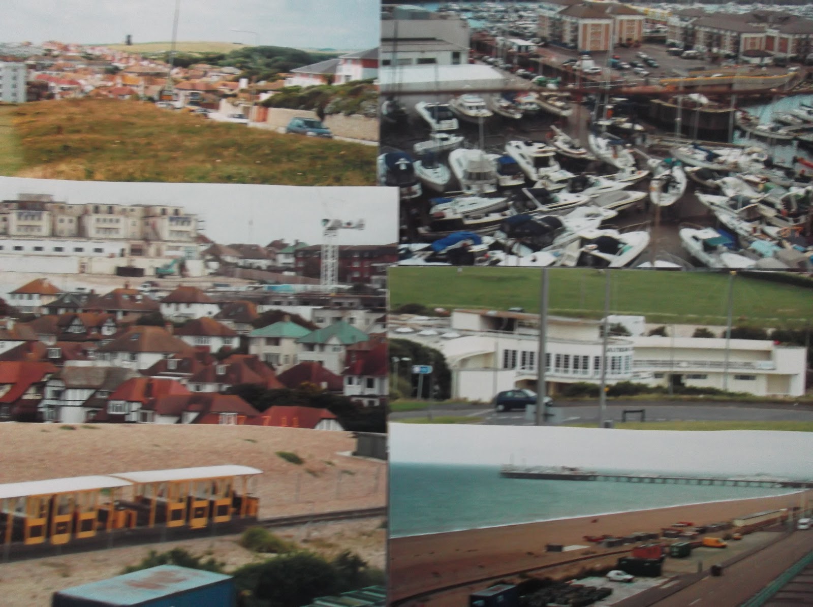
The walk continues to Telscombe Cliffs then there is a short gap before arriving at Saltdean. Two buildings are of note here. The first, Saltdean Lido, built in 1938, is a fine example of the architecture of the time. It was in danger of being closed recently but has been saved. In the background and dominating the skyline is the ex Grand Ocean Hotel built at the same time as the Lido. This was used as a fire service centre during the Second World War and after this it was owned by Butlins. From 1999 until 2005 it became a hotel again and has now been converted to apartments.

About half a mile further along is Rottingdean. The black Rottingdean Windmill can be seen high up on a hill near the village. It was built in 1802 and has been restored with the help of a lottery grant. It is worth a break from the walk to have a look at Rottingdean village. For most of its history it has been a farming community but from the 18th century it attracted visitors who came here as an alternative to Brighton. Rudyard Kipling’s old house can be seen and the artist Sir William Nicholson’s residence has been converted into a museum and library. If you ever watched the bizarre and funny TV series The League of Gentleman you might be interested to know that The Old Customs House Shop was the inspiration for  – ‘a local shop for local people’.

Returning to the coastal path, which is close to the main road, the next landmark is Roedean School. This famous private school for girls was founded in 1885. During the Second World War the girls moved to Keswick when the Admiralty used the building for training naval cadets. Girls from 11 -18 years old attend the school. Up on the hill near to this point is the famous St Dunstan’s Training Centre for the Blind.

A little further along is the impressive Brighton Marina which is the largest in Europe with 1600 berths. It was built between 1971 and 1979 but has grown since with a number of facilities and attractions added over the years e.g. a supermarket, restaurants, cinemas, bowling alley. 

The walk along Brighton seafront features many impressive buildings. At one point you can look up the hill and see the grandstand of Brighton Racecourse. If you like horse racing it is worth a visit during the summer meetings.

Near to the promenade is the famous Volk’s Electric Railway which runs from the Palace Pier to the marina. Built in 1883, it was Britain’s first electric seafront railway. Magnus Volk, the son of a German clockmaker, was the designer and builder.  At one stage a tall contraption called Daddy Long Legs ran along a special track and gave excursions out into the shallow water of the sea. A storm and some financial problems in the early twentieth century meant that this project had to be abandoned after a few years. Further details can be found on the company’s website: volkselectricrailway.co.uk.

The next landmark is the Palace Pier where this walk ends. In its original form in 1823 it was a Chain Pier which was used for passenger ships arriving from Dieppe in France. Following storm damage it had to be completely rebuilt. This took ten years and other attractions such as amusement machines and palm readers were introduced from 1905. A theatre and bandstand were opened soon after this. It remains very popular with updated rides, games, food outlets etc.

Snaps show: view of Rottingdean; Brighton Marina; Saltdean with old Ocean Hotel in background; Saltdean lido; Volks railway; Palace Pier.


Monday, 7 January 2013

Walk 87 Cuckmere Haven to Newhaven


Walk   87 Cuckmere Haven to Newhaven (East Sussex)

(Second leg of English coastal walk – Broadstairs to Lands End)

Map: L/R 199 and 198
Distance: about 6 miles or 10 km.
Difficulty:  Moderate – some cliff walking
Terrain: footpaths including cliff paths and pavement
Access: Parking at both ends (off A259 at Cuckmere Haven)
Public transport: 12, 12A and 13 buses run between Eastbourne and Brighton past Cuckmere Haven and Newhaven.

Start at Exceat Bridge and follow the path along the western side of the Cuckmere River down to the coastal path which is part of The Vanguard Way. This path was developed in the 1980s to celebrate the 15th anniversary of the Vanguard Rambling Club. They adopted this name when they had to travel in the guard’s van of a train after finishing a walk. The path starts in east Croydon and ends in Newhaven.

On the hill overlooking Cuckmere Haven is a small memorial commemorating the dead in World War 2, presumably this includes those killed by German aircraft which bombed army tents camped here in 1940. The walk continues along the cliff top past Hope Gap and along to Seaford Head. There is a good view of Seaford and the cliffs near Brighton. When I walked this stretch the Isle of Wight could also be seen in the distance.

The path descends to Seaford sea front. The beach here faces south west and violent storms sometimes hurl shingle on to the road. The cliffs back to the east provide a stunning back drop. The large, impressive white building on the land side is Corsica Hall. I was told that this was originally built on the proceeds of smuggled Corsican wine – hence its name.

Seaford was an important port in the middle ages but declined when it silted up in the sixteenth century. The River Ouse, on which it used to stand, was rerouted to Newhaven. A little further along the front is a smart looking Martello Tower which has a cannon on its roof; this building houses the town’s museum.

About a mile out of Seaford is an area called Tide Mills. A mill and some cottages were on this site. The foundations of the former Chailey Heritage Hospital are still clearly visible and the whole area has been tidied up by offenders as part of Community Punishment Orders. The hospital was built in 1924 for boys with physical disorders to recover after an operation. The mill used tides to grind flour and supported a thriving village in the 1800s. A brief history of the now deserted village of Tide Mills can be found on information boards and in the local museum.

The walk inland to Newhaven has to be navigated carefully alongside the industrial buildings and involves crossing the railway line. There is a good view of the River Ouse and harbour from the bridge linking the two parts of Newhaven. On the west side of the river are some expensive looking residential buildings.  Newhaven is a busy port with area of light industry and a ferry service to France. Look out for the toilets near Newhaven FC which claim to be the last before France!  At one time Newhaven had an unusual trade in flints (often called boulders) which were gathered from the beaches and sent to the potteries in the midlands.

No visit to Newhaven is complete without a visit to the famous fort on the cliff top. This virtually impregnable building was originally constructed to repel the French in Napoleonic times and was later adapted to rebuff the threat of a German invasion in the Second World War. 

The walk finishes at this point.

Snaps show: Martello Tower at Seaford; the 'last toilets' Newhaven; Tide Mills - hospital foundations; The site of Newhaven Fort.